
Relatives
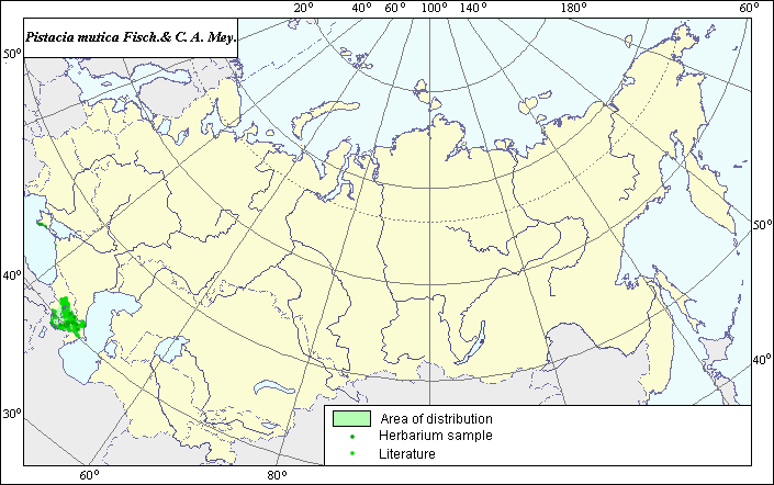
The distribution area of Pistacia mutica Fisch. & C. A. Mey. (Turkterebinth or wild pistachio)
 Object description Download GIS-layers
Authors:
Expert botanist T.N. SmekalovaGIS-expert G.V. Talovina
Date of creation:
18.12.2003Scale:
1:20,000,000.Accuracy of map:
Map was created using herbarium specimens and maps of scale 1:10,000,000.The projection:
"Alber's Equal Area Conic for Russia", 9, 1001, 7, 100, 0, 44, 68, 0, 0.Basic content:
Map is a vector file consisting of a polygon and points. Locations of the species are represented by points, while the area of possible distribution of the species is represented by a polygon.Accuracy of qualifier:
Light-colored points represent species locations referenced in published sources. Dark-colored points represent locations from which herbarium samples were taken. Polygon is based on generalized information from published sources, herbarium specimens, political boundaries and ecological descriptions.Method of map construction:
The mapped distribution area of Pistacia mutica was created using herbarium data from the Komarov Botanical Institute (LE), the Vavilov Institute of Plant Industry (VIR) and references, namely Grossgeim (1962), Cherepanov (1995), and Shishkin (1950). The species distribution area is comprised of three regions: one Crimean and two Caucasian. All regions were mapped in accordance with published data on species distribution within the former USSR (Shishkin, 1950; Grossgeim, 1962; Sokolov & Svyazeva, 1986). The Crimean region includes the southern part of the Crimea peninsula. In the Caucasus, the species distribution area covers Transcaucasia and the western part of the Northwestern Caucasus. The southwestern border of both Caucasian regions coincides with the state border of the former USSR. The eastern border of the larger Caucasus region and the western border of the smaller Caucasus region coincide with the coastal line of the Caspian and Black Seas. The northern and southern borders of the Caucasian regions were mapped using herbarium data.Sources of data:
Cherepanov S.K., 1995. Plantae Vasculares Rossicae et Civitatum Collimitanearum (in limicis USSR olim). St. Petersburg, Mir I Semia, 990 p. (in Russian).Grossgeim A.A. 1962. Flora of the Caucasus. Vol. 6. Moscow-Leningrad: Publishing House of Russian Acad. Science, p. 101.
Herbarium Specimens. Vavilov Institute of Plant Industry (St. Petersburg, Russia), Komarov Botanical Institute (St. Petersburg, Russia).
Kordon R.J. 1936. Turkterebinth. Flora of cultivated plants. Vol. 17. Moscow-Leningrad, State Agricultural publishing company, pp. 313-339. (in Russian).
Lavrenko E.M., Soczava V.B., eds. 1956. Descriptio vegetationis URSS. Vol. 1-2. Redactoribus Editio academiae scientiarum URSS. Mosqua-Leningrad. P. 400, 578.
Shishkin B.K., Bobrov E.G., eds. 1949. Flora of the USSR. Vol. 14. M.-L.: Publishing House of the USSR Academy of Sciences, p. 524-525. (in Russian).
Sokolov S.J., Svjazeva O.A. eds. 1986. Areas of trees and bushes of the USSR. Vol. 3. Leningrad: Nauka. P. 58. (in Russian).
Wulf E.W., Maleeva O.F. 1969. The world resources of the useful plants. Leningrad: Nauka, p. 275.
Right and copyright:
Copyright on the map and its description belongs to its authors.Copyright on the picture belongs to Sergey Shuvalov.