
Relatives
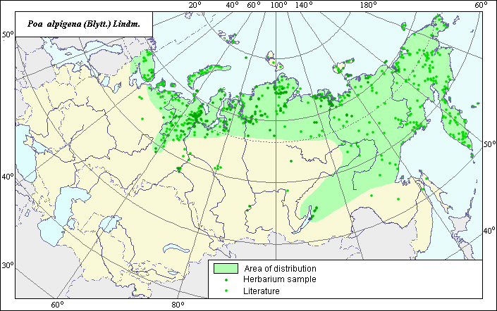
Distribution area of high-mountain bluegrass (Poa alpigena (Blytt.) Lindm.).
 Object description Download GIS-layers
Authors:
Experts N.I. Dzyubenko & E.A. DzyubenkoGIS-expert A.N. Dzyubenko
Date of creation:
17.09.2005Scale:
1:20,000,000.Exactness of map:
The map was created using maps of scale 1:10,000,000-1:80,000,000.The projection:
"Alber's Equal Area Conic for Russia", 9, 1001, 7, 100, 0, 44, 68, 0, 0.Basic contents:
Map is a vector file consisting of polygons and points. Locations of the species are represented by points, while the area of possible distribution of the species is represented by polygons.Exactness of classifier:
Light-colored points represent species locations referenced in published sources. Dark-colored points represent species locations reported in the VIR database (N.I. Vavilov All-Russian Research Institute of Plant Industry) and BIN database (the Komorov Institute of Botany). Polygons are based on published sources, herbarium samples, political boundaries and ecological descriptions.Method of map construction:
To construct the distribution area of Poa alpigena, published maps of species distribution (Tolmachev, 1964; Harkevich, 1985; Hulten & Fries, 1986) and herbaria data (Komarov Botanical Institute (BIN), N.I. Vavilov All-Russian Institute of Plant Industry (VIR), St. Petersburg) were used. Our map of species distribution within Russia nearly coincides with that of Hulten & Fries (1986). The species distribution area, which was created by generalizing available data, is presented as one large polygon, three small polygons (green line) and separate points, which correspond to published data on species distribution (Rodjevitz & Schischkin, 1937; Fedorov, 1974; Tzvelev, 1976; Malyshev & Peshkova, 1994). The distribution area borders are based on all available data. The largest polygon covers arctic Russia, the Urals, Siberia and the Far East. The points, which were not included in the polygons, represent single sites of the species. The distribution area borders take into account the ecological preferences of the species.Sources of data:
Database of VIR materials (N.I. Vavilov All-Russian Institute of Plant Industry) and BIN materials (Komorov Institute of Botany).Fedorov A.A., ed. 1974. Flora of the European part of the USSR. Vol. 1. L.: Nauka, 404 pp. (in Russian).
Harkevich S.S., ed. 1985. Vascular Plants of the Soviet Far East. Vol. 1. St. Petersburg: Nauka, 390 p. (in Russian).
Hulten E., Fries M. 1986. Atlas of Northern European vascular plants north of the Tropic of Cancer. Vol. 1-3. Konigstein, 1172 p.
Malyshev L.I., Peshkova G.A., eds. 1994. Flora of Siberia. Vol. 2. Novosibirsk: Nauka, 361 pp. (in Russian).
Rodjevitz P.U., Schischkin V.K., eds. 1937. Flora of the USSR. Vol. 2. M.-L.: USSR, 778 pp. (in Russian).
Tolmachev A.I., ed. 1964. Arctic flora of the USSR. Vol. 2. M.-L.: Nauka, 273 p. (in Russian).
Tzvelev N.N. 1976. Poaceae USSR. L.: Nauka, 788 pp. (in Russian).
Rights and copyrights:
Copyright on the map and its description belongs to its authors.Copyright on the photos belongs to N.I. Dzyubenko.