
Relatives
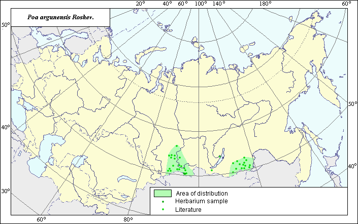
Distribution area of argun bluegrass (Poa argunensis Roshev.).
 Object description Download GIS-layers
Authors:
Experts N.I. Dzyubenko & E.A. DzyubenkoGIS-expert A.N. Dzyubenko
Date of creation:
27.06.2005.Scale:
1:20,000,000.Exactness of map:
The map was created using maps of scale 1:25,000,000.The projection:
"Alber's Equal Area Conic for Russia", 9, 1001, 7, 100, 0, 44, 68, 0, 0.Basic contents:
Map is a vector file consisting of a polygon and points. Locations of the species are represented by points, while the area of possible distribution of the species is represented by a polygon.Exactness of classifier:
Light-colored points represent species locations referenced in published sources. Dark-colored points represent species locations reported in the BIN database (the Komorov Institute of Botany). The polygon is based on published sources, herbarium samples, political boundaries and ecological descriptions.Method of map construction:
To construct the distribution area of Poa argunensis, a published map of species distribution (Malyshev & Peshkova, 1990) and herbaria data (Komarov Botanical Institute (BIN), St. Petersburg) were used. The species originated in Mongolia (Tzvelev, 1976). The final species distribution area within Russia is presented as two polygons (green line) and separate points. The points, which were not used to construct the polygons, represent single locations of the species. The distribution area borders take into account the ecological preferences of the species.Sources of data:
Database of VIR materials (N.I. Vavilov All-Russian Institute of Plant Industry) and BIN materials (Komorov Institute of Botany).Malyshev L.I., Peshkova G.A., eds. 1990. Flora of Siberia. Vol. 2. Novosibirsk: Nauka, 361 pp. (in Russian).
Tzvelev N.N. 1976. Poaceae USSR. L.: Nauka, 788 pp. (in Russian).
Rights and copyrights:
Copyright on the map and its description belongs to its authors.Copyright on the photos belongs to N.I. Dzyubenko.