
Relatives
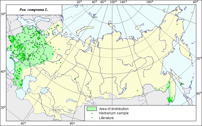
Distribution area of Canadian bluegrass (Poa compressa L.).
 Object description Download GIS-layers
Authors:
Experts N.I. Dzyubenko & E.A. DzyubenkoGIS-expert A.N. Dzyubenko
Date of creation:
17.09.2005Scale:
1:20,000,000.Exactness of map:
The map was created using maps of scale 1:10,000,000-1:80,000,000.The projection:
"Alber's Equal Area Conic for Russia", 9, 1001, 7, 100, 0, 44, 68, 0, 0.Basic contents:
Map is a vector file consisting of polygons and points. Locations of the species are represented by points, while the area of possible distribution of the species is represented by polygons.Exactness of classifier:
Light-colored points represent species locations cited in published literature. Dark-colored points represent species locations reported in the VIR database (N.I. Vavilov All-Russian Research Institute of Plant Industry) and the BIN database (Komorov Institute of Botany). Polygons are based on published sources, herbarium samples, political boundaries and ecological descriptions.Method of map construction:
To construct the distribution area of Poa compressa, published maps of species distribution (Grossheim, 1939; Cereals of Ukraine, 1977; Harkevich, 1985; Hulten & Fries, 1986), data from the N.I. Vavilov All-Russian Institute of Plant Industry (VIR) (St. Petersburg) and herbaria data (Komarov Botanical Institute (BIN) (St. Petersburg) were used. According to published data, the species is distributed across the European part of Russian Baltic countries, Byelorussia, Moldova, Ukraine, the Crimea, the Caucasus and the Far East (Rozhevitz & Shishkin, 1937; Fedorov, 1974; Tzvelev, 1976; Brezhnev & Korovina, 1980). The presented distribution area, which was created generalizing all available data, consists of two separate polygons (green line) and separate points. The species was introduced into Far East, where it has naturalized. The points, which were not included in the polygons, represent single sites of the species. The distribution area borders are based on all available data.Sources of data:
Brezhnev D.D., Korovina O.N. 1980. Wild relatives of the cultivated plants of flora of the USSR. L.: Kolos, 376 pp. (in Russian).Cereals of Ukraine. 1977. Kiev: Naukova Dumka, 518 pp. (in Russian).
Database of VIR materials (N.I. Vavilov All-Russian Institute of Plant Industry) and BIN materials (Komorov Institute of Botany).
Fedorov A.A., ed. 1974. Flora of the European part of the USSR. Vol. 1. L.: Nauka, 404 pp. (in Russian). Grossheim A.A. 1939. Flora of the Caucasus. Vol. 2. Polypodiaceae-Gramineae. Baku: Publishing house AzFaN. 587 p.
Harkevich S.S., ed. 1985. Vascular Plants of the Soviet Far East. Vol. 5. St. Petersburg: Nauka, 390 p. (in Russian)
Hulten E., Fries M. 1986. Atlas of Northern European Vascular Plants North of the Tropic of Cancer. Vol. 1-3. Konigstein, 1172 p.
Rozhevitz P.U., Shishkin V.K., eds. 1937. Flora of the USSR. Vol. 2. M.-L.: USSR, 778 pp. (in Russian).
Tzvelev N.N. 1976. Poaceae USSR. L.: Nauka, 788 pp. (in Russian).
Rights and copyrights:
Copyright on the map and its description belongs to its authors.Copyright on the photos belongs to N.I. Dzyubenko.