
Relatives
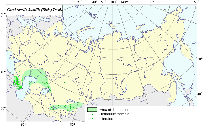
Distribution area of low catabrosella - Poa humilis Bieb.
 Object description Download GIS-layers
Authors:
Object expert and GIS-expert L.L. MalyshevDate of creation:
21.09.2005Scale:
1:20,000,000.Accuracy of map:
Map was created using maps of scale 1:2,000,000-1:11,250,000.Projection:
"Alber.s Equal Area Conic for the USSR", 9, 1001, 7, 100, 0, 44, 68, 0, 0.Basic contents:
Vector map consisting of 1 base and 3 thematic layers. The species distribution area is shown by polygons and points.Accuracy of qualifier:
Points represent species locations referenced in published literature and original locations of L.E. herbarium specimens. The polygon was constructed using generalized information on species distribution.Mapping procedure:
The map is based on species locations provided by the L.E. herbarium and published maps from Grossheim (1939). The species is distributed throughout the zone of dry and desert steppes. In the Caucasus, the Lower Volga region and Western Kazakhstan, the more prominent species is actually Catabrosella humilis subsp. Humilis. In Eastern Kazakhstan (Balkhash region and foothills of Tien Shan), the subspecies C. humilis subsp. songorica Tzvel is more prominent.Sources of data:
Grossheim A.A. 1939. Flora of the Caucasus. Vol. 2. Polypodiaceae-Gramineae. Baku: Publishing house AzFaN. 587 p.Rights and copyrights:
All rights to the map and its description belong to its author.Copyright on the photos belongs to E. Dzyubenko.