
Relatives
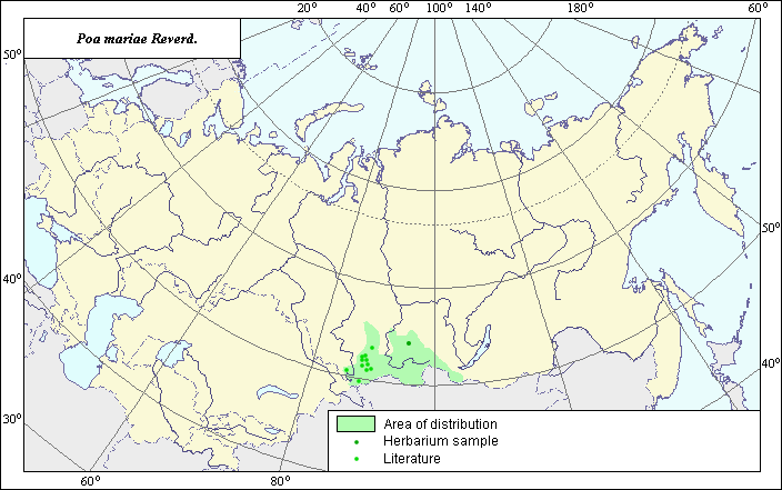
Distribution area of Poa mariae Reverd.
 Object description Download GIS-layers
Author:
V.G. FuntovaData of creation:
09.06.2004.Scale:
1:20,000,000.Exactness of map:
The map was created using maps of scale 1:50,000,000.Projection:
.Alber's Equal Area Conic for Russia., 9, 1001, 7, 100, 0, 44, 68, 0, 0.Basic content:
Vector map. Locations of the species are represented by points, while the area of possible distribution of the species is represented by polygons.Exactness of classifier:
Points of different colors represent species locations referenced in published literature and locations from which herbarium specimens were taken.Method of map construction:
Point area includes species locations reported in Malyshev & Peshkova (1990) and locations from which V.L. Komarov Botanical Institute herbarium specimens were taken. Polygons were constructed using species distribution data from Tzvelev (1976). The final map legend is bi-colored. Dark points represent locations from which herbarium specimens were taken. Light points represent species locations referenced in published literature. The western border was mapped using Malyshev & Peshkova (1990). The northern and eastern borders were mapped using herbarium data from the V.L. Komarov Botanical Institute and Tzvelev (1976). The southern border matches the state border of Russia. The distribution area map takes into account the ecological preferences of the species.Sources of data:
Herbaria of the V.L. Komarov Botanical Institute.Malyshev L.I., Peshkova G.A., eds. 1990. Flora of Siberia. Vol. 2. Novosibirsk: Nauka, 361 pp. (in Russian).
Tzvelev N.N. 1976. Poaceae USSR. L.: Nauka, 788 pp. (in Russian).