
Relatives
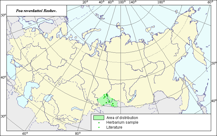
Distribution area of Poa reverdattoi Roshev.
 Object description Download GIS-layers
Author:
V.G. FuntovaData of creation:
28.06.2004.Scale:
1:20,000,000.Exactness of map:
The map was created using maps of scale 1:50,000,000 and 1:10,000,000.Projection:
.Alber's Equal Area Conic for Russia., 9, 1001, 7, 100, 0, 44, 68, 0, 0.Basic content:
Map is vectorial. Locations of the species are represented by points, while the area of possible distribution of the species is represented by a polygon.Exactness of classifier:
Points of different colors represent species locations referenced in published literature and locations from which herbarium samples were taken.Method of map construction:
Point area includes species locations from Malyshev & Peshkova (1990) and original locations of specimens at the V.L. Komarov Botanical Institute herbarium. The polygon was constructed using species distribution data from Tzvelev (1976). The final map legend is bi-colored. Dark-colored points represent locations from which herbarium samples were taken. Light-colored points represent species locations referenced in published literature. The polygon is the result of integrating data from Malyshev & Peshkova (1990) and the V.L. Komarov Botanical Institute herbarium with the southern state border of Russia. One point was not included in the polygon, as there was insufficient data on species distribution in this area. The distribution area map takes into account the ecological preferences of the species.Sources of data:
Herbaria of the V.L. Komarov Botanical Institute.Malyshev L.I., Peshkova G.A., eds. 1979. Flora of Central Siberia. Vol. 1. Onocleaceae-Saxifragaceae. Novosibirsk: Nauka, 431 pages.
Malyshev L.I., Peshkova G.A., eds. 1990. Flora of Siberia. Vol. 2. Poaceae (Gramineae). Novosibirsk: Nauka, 361 pages.
Tzvelev N.N. 1976. Cereals of the USSR. Leningrad: Nauka, 788 pages.