
Relatives
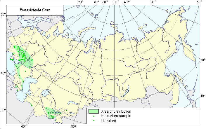
Distribution area of forest bluegrass (Poa sylvicola) .
 Object description Download GIS-layers
Authors:
Object expert and GIS-expert L.L. MalyshevDate of creation:
29.06.2005Scale:
1:20,000,000.Accuracy of map:
Map was created using maps of scale 1:2,000,000-1:11,250,000.Projection:
"Alber.s Equal Area Conic the USSR", 9, 1001, 7, 100, 0, 44, 68, 0, 0.Basic contents:
Vector map consisting of 1 base and 3 thematic layers. The species distribution area is shown by polygons and points.Accuracy of qualifier:
Points represent locations from which L.E. herbarium samples were taken and species locations referenced in published literature. The polygon was created using general species distribution data from published sources.Mapping procedure:
The species distribution area was mapped using L.E. herbarium specimens and Shelyag-Sosonko (1977). In the European part of the former USSR, the species is distributed throughout the forest-steppe zone from the Carpathian Mountains to the Volga, as well as through the woods of the middle mountain belt of the Caucasus and Crimean Mountains. In Central Asia, the species occurs in the mountains of Kopet-Dag and in the middle mountain belt of Pamir-Alay and Western Tien-Shan.Source of data:
Shelyag-Sosonko Yu.R., ed. 1977. Cereals of Ukraine. Kiev: Naukova Dumka, 518 p.Rights and copyrights:
All rights to the map and its description belong to its author.Copyright on the photos belongs to E. Dzyubenko.