
Relatives
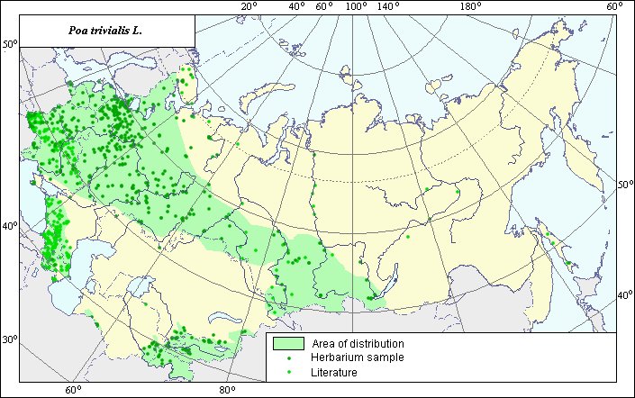
Distribution area of rough-stalked bluegrass (Poa trivialis L.).
 Object description Download GIS-layers
Authors:
Experts N.I. Dzyubenko & E.A. DzyubenkoGIS-expert A.N. Dzyubenko
Date of creation:
17.09.2005Scale:
1:20,000,000.Exactness of map:
The map was created using maps of scale 1:10,000,000-1:80,000,000.The projection:
"Alber's Equal Area Conic for Russia", 9, 1001, 7, 100, 0, 44, 68, 0, 0.Basic contents:
Map is a vector file consisting of polygons and points. Locations of the species are represented by points, while the area of possible distribution of the species is represented by polygons.Exactness of classifier:
Light-colored points represent species locations referenced in published literature. Dark-colored points represent species locations reported in the VIR database (N.I. Vavilov All-Russian Research Institute of Plant Industry) and BIN database (the Komorov Institute of Botany). Polygons are based on published sources, herbarium samples, political boundaries and ecological descriptions.Method of map construction:
To construct the distribution area of Poa trivialis, published maps of species distribution (Grossheim, 1939; Cereals of Ukraine, 1977; Hulten & Fries, 1986), herbaria data (Komarov Botanical Institute (BIN)), and collected germplasm data (N.I. Vavilov All-Russian Institute of Plant Industry (VIR), St. Petersburg) were used. The area has disjunctive quality and consists of four polygons and separate points. The largest polygon occupies the European part of the former USSR (except the Arctic and dry steppe zone) and Southwestern Siberia. In the south, there are two polygons that cover the mountainous regions of Central Asia. In the southwest, there is one polygon that covers the mountainous region of the Caucasus (except Talysh and the Kura lowland). The distribution area borders were mapped using all available data. The small polygons mapped by Hulten & Fries (1986) in the plain zone of Central Asia have not been confirmed by our data or other published data (Kovalevskaja, 1968). The points, which were not included into borders of contours, represent secondary, invasive sites of species.Sources of data:
Cereals of Ukraine. 1977. Kiev: Naukova Dumka, 518 pp. (in Russian).Database of VIR materials (N. I. Vavilov All-Russian Institute of Plant Industry) and BIN materials (Komorov Institute of Botany).
Grossheim A.A. 1939. Flora of the Caucasus. Vol. 2. Polypodiaceae - Gramineae. Baku, Publishing house AzFaN, 587 pages.
Hulten E., Fries M. 1986. Atlas of Northern European Vascular Plants North of the Tropic of Cancer. Vol. 1-3. Konigstein, 1172 p.
Kovalevskaja S.S., ed. 1968. Conspect of Middle Asian Flora. Vol. 1. Taschkent: AN Uzbekistan SSR, 226 pp. (in Russian).
Rights and copyrights:
Copyright on the map and its description belongs to its authors.Copyright on the photos belongs to N.I. Dzyubenko.