
Relatives
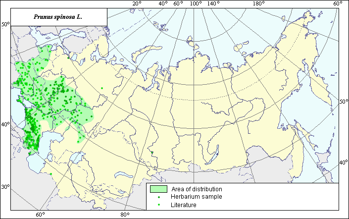
The distribution area of slow blackthorn (Prunus spinosa L.).
 Object description Download GIS-layers
Authors:
Expert botanist I.G. ChukhinaGIS-expert T.A. Sinitsyna
Date of creation:
24.12.2004.Scale:
1:20,000,000.Exactness of map:
Map was created using herbarium specimens and maps of scale 1:13,000,000-1:80,000,000.The projection:
"Alber's Equal Area Conic for Russia", 9, 1001, 7, 100, 0, 44, 68, 0, 0.Basic contents:
Map is a vector file consisting of polygons and points. Locations of the species are represented by points, while areas of possible distribution of the species are represented by polygons.Accuracy of classifier:
Points represent locations of the species referenced in published sources and locations from which herbarium specimens were taken. Polygons are based on generalized information from published sources and herbarium specimens.Method of map production:
Species location data were obtained from a database of species locations, the INFORMATION RETRIEVAL SYSTEM, "Wild-growing relatives of cultural plants of Russia" (NTC "Informregistr" № 0229905883, 1999) and from maps in Grossgeim (1952), Sokolov et al (1980) and Hulten & Fries (1986). The species has a disjunctive distribution area. In the European part of the distribution area, the western border was drawn using Hulten & Fries (1986). The northwestern and eastern borders were mapped in accordance with Hulten & Fries (1986) and Sokolov et al (1980). The northern border was constructed in accordance with information from herbarium specimens in the IRS database (1999). Borders of the Central Asiatic part of the distribution area (Kopet dagh) were constructed using Sokolov et al (1980). Two locations (in the Northwestern European part and in Western Siberia) were not included in the polygons because they most likely represent the escape of the species from cultivated crops rather than natural occurrence.References.
Grossgeim A.A. 1952. Flora of the Caucasus. Vol. 5. Moscow/Leningrad: Publishing House of the USSR Academy of Sciences, Map #163. (in Russian).Herbarium of the N.I. Vavilov All-Russian Institute of Plant Industry (WIR) (St. Petersburg, Russia) and Moscow State University.
Hulten E., Fries M. 1986. Atlas of Northern European Vascular Plants North of the Tropic of Cancer. Vol. 1-3. Konigstein, 1172 p.
Information Retrieval System (IRS), "Wild relatives of cultural plants of Russia", 1999. N.I. Vavilov All-Russian Institute of Plant Industry (WIR) (St. Petersburg, Russia) NTC "Informregistr" № 0229905883.
Sokolov S.I., Svjaseva O.A., Kubli V.A. 1980. Areas of distribution of trees and shrubs in the USSR. Vol. 2. Leningrad: Nauka, Map #91A.
Right and copyright:
Copyright on this map and its description belongs to its authorsCopyright on the picture belongs to Jacint Ribas ( http://www.xtec.es/col-anunciata-cerdanyola/plantes )