
Relatives
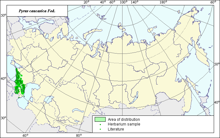
The distribution area of Caucasian pear (Pyrus caucasica Fed.).
 Object description Download GIS-layers
Authors:
Expert botanist I.G. ChukhinaGIS-expert T.A. Sinitsyna
Date of creation:
15.12.2004Scale:
1:20,000,000Accuracy of map:
Map was creates using herbarium specimens and maps of scale 1:13,000,000-1:25,000,000.The projection:
"Alber's Equal Area Conic for Russia", 9, 1001, 7, 100, 0, 44, 68, 0, 0.Basic contents:
Vector map. Area of species distribution is shown by polygons, while actual location occurrence is shown by points.Accuracy of classifier:
Point data were obtained from published sources and herbarium specimens. Polygons are based on published sources, herbarium samples, and field surveys by the authors.Method of map production:
Published literature was reviewed, including atlases, monographs and papers. Occurrence data were obtained from herbarium specimens, floras, monographs and papers. The following sources were consulted: the N.I. Vavilov Institute (1999), Grossgheim (1952), and Sokolov et al (1980). Data were compiled through scanning and geo-referencing to develop a composite vector map. The biologist, together with the GIS-specialist, drew a new plant distribution area based on compiled data. The species has a disjunctive area. In the Caucasus, the borders of the distribution area were drawn in accordance with Grossgheim (1952) and Sokolov et al (1980) and were corrected using information from VIR database herbarium specimens (N.I. Vavilov Institute, 1999). In the Talysh, the distribution area borders were constructed using VIR herbarium specimens.Reference citations:
Grossgeim A.A. 1952. Flora of the Caucasus. Vol. 5. Moscow-Leningrad: Publishing House of the USSR Academy of Sciences. Map #11. (In Russian)N.I. Vavilov All-Russian Institute of Plant Industry [VIR], St. Petersburg, Russia.
N.I. Vavilov Institute, Herbarium Department, 1999. Information retrieval system: Wild-growing relatives of cultural plants of Russia. STC Informregistr 0229905883, St. Petersburg, Russia.
Sokolov S.I., Svjaseva O.A., Kubli V.A. 1980. Areas of distribution of trees and shrubs in the USSR. Vol. 2. Leningrad: Nauka. Map #50A.