
Relatives
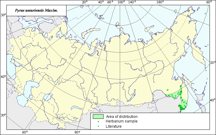
The area of Ussurian pear. - Pyrus ussuriensis.
 Object description Download GIS-layers
Authors:
Expert botanist I.G. ChuhinaGIS-expert O.V. Pereloma
Date of creation:
25.04.2005Scale:
1:20,000,000.Accuracy of map:
Map was created using herbarium specimens and maps of scale 1:20,000,000-1:50,000,000.The projection:
"Alber's Equal Area Conic for Russia", 9, 1001, 7, 100, 0, 44, 68, 0, 0.Basic contents:
Map is a vector file consisting of a polygon and points. Locations of the species are represented by points, while the areas of possible distribution of the species are represented by a polygon.Accuracy of qualifier:
Points represent species locations referenced in published sources and locations from which herbarium specimens were taken. Polygon is based on generalized information from published sources and herbarium specimens.Method of map construction:
The species distribution data were obtained from a database of species locations, the Information Retrieval System, "Wild-growing relatives of cultural plants of Russia" (NTC "Informregistr" № 0229905883), and from the following sources: Sokolov et al. (1980), Kharkevich (1996) and Koropachinskiy & Vstovskaya (2002). The distribution area borders were mapped in accordance with Koropachinskiy & Vstovskaya (2002). The northern and western borders of the area were extended in accordance with Kharkevich (1996) and information on herbarium specimens from the IRS database. Two species locations outside the polygon were not used to determine the main distribution area. These two sites require additional investigation.References:
Herbarium Specimens. Komarov Botanical institute (LE), Vavilov All-Russian Institute of Plant Industry (WIR) (St. Petersburg, Russia), Institute of biology and soil science FEP RAS (Vladivostok, Russia).Information Retrieval System (IRS), "Wild relatives of cultural plants of Russia". 1999. N.I. Vavilov All-Russian Institute of Plant Industry (WIR) (St. Petersburg, Russia) NTC "Informregistr" № 0229905883.
Kharkevich S.S., ed. 1996. Vascular plants of the Soviet Far East. Vol. 8. Leningrad: Nauka, Map #43G. (in Russian).
Koropachinskiy I.Yu., Vstovskaya T.N. 2002. Woody plants of the Asian part of Russia. Novosibirsk: Publishing House of SB RAS, Branch "Geo", p.351 (in Russian).
Sokolov, S.I., Svjaseva, O.A., Kubli, V.A. 1980. Areas of distribution of trees and shrubs in the USSR. vol.2. Leningrad: Nauka, Map #48B. (in Russian).
Right and copyright:
Copyright on this map and its description belongs to its authors.Copyright on the picture belongs to A. Sorokin and T.A. Sinitsyna.