
Relatives
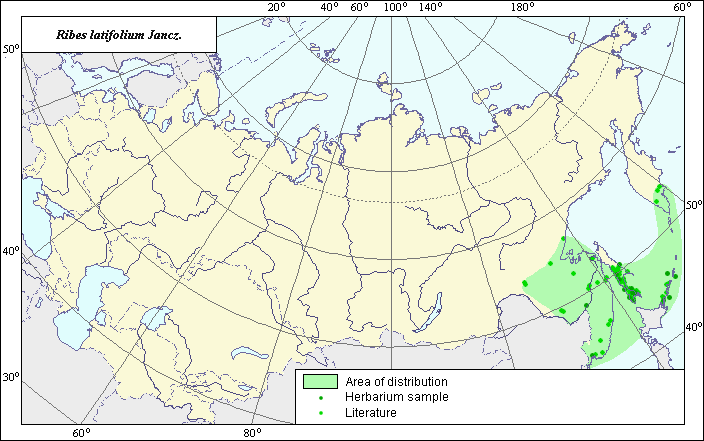
The distribution area of Broad-leaved currant (Ribes latifolium Jancz.)
 Object description Download GIS-layers
Authors:
Expert botanist T.N. SmekalovaGIS-expert G.V. Talovina
Date of creation:
29.10.2003.Scale:
1:20,000,000.Accuracy of map:
Map was created using herbarium materials and maps of scale 1:25,000,000-1:46,200,000.The projection:
"Alber's Equal Area Conic for Russia", 9, 1001, 7, 100, 0, 44, 68, 0, 0.Basic contents:
Vector map. Polygons and points represent distribution of the species.Accuracy of classifier:
The distribution area of the species was mapped following an analysis of published maps and herbarium materials. This map is based on the distribution of Ribes latifolium shown in Harkevich (1988) as well in the other sources specified below. Dark points represent collection locations of herbarium specimens (N.I. Vavilov Institute). Lighter points represent species occurrence noted in Koropachinsky & Vstovskata (2002).Method of map production:
Published literature was reviewed, including atlases, monographs and papers. Occurrence data were obtained from herbarium specimens, floras, monographs and papers. Data were then compiled through scanning and geo-referencing to develop a composite vector map. The biologist, together with the GIS-specialist, drew a new plant distribution area based on compiled data.Reference citations:
Harkevich S.S., ed. 1988. Vascular plants of the Soviet Far East. Vol. 3. Leningrad: Nauka, 123, 126 pp. (In Russian)Koropachinsky I.Yu., Vstovskata T.N. 2002. Woody plants of Asiatic Russia. Novosibirsk: Siberian Division of the Russian Academy of Science, GEO Branch Publishers, 282 pp. (In Russian)
N.I. Vavilov Institute of Plant Industry [VIR], St. Petersburg, Russia.
V.L. Komarov Botanical Institute [LE], St. Petersburg, Russia.