
Relatives
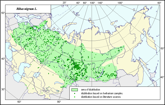
The distribution area of Black currant (Ribes nigrum (Jancz.) Pojark.)
 Object description Download GIS-layers
Authors:
Expert-botanist T.N. SmekalovaGIS-expert G.V. Talovina
Date of creation:
01.08.2003Scale:
1:20,000,000.Accuracy of map:
Map was created using herbarium materials and maps of scale 1:12,000,000-1:40,000,000.The projection:
"Alber's Equal Area Conic for Russia", 9, 1001, 7, 100, 0, 44, 68, 0, 0.Basic contents:
The vector map consists of 1 base layer and 3 thematic layers. The species distribution area is shown by polygons and points.Accuracy of qualifier:
Points represent species locations referenced in published literature and from which herbarium specimens were taken. The polygon was created using generalized information on species distribution from published references and herbariums.Mapping procedure:
The distribution area map is based on herbarium materials and the published maps of Malyshev & Peshkova (1979), Tolmachyov (1983) and Koropachinsky (1983).Sources of data:
Database of coordinates of a site of the species, INFORMATION RETRIEVAL SYSTEM, "Wild-growing relatives of cultural plants of Russia" (NTC "Informregistr" № 0229905883).Malyshev L.I., Peshkova G.A., eds. 1979. Flora of Central Siberia. Vol. 1. Novosibirsk: The Science, P. 8, 431.
Koropachinsky I.JU. 1983. Woody plants of Siberia. Novosibirsk: Nauka, P. 195.
Materials of the herbariums of the Central Siberian Botanical Garden, Moscow State University, Komarov Botanical Institute (BIN), Voronezh State University and Uljanovsk Pedagogical University.
Tolmachyov A.I., ed. 1983. Atlas of areas and resources for medicinal plants of the USSR. M., P. 90, 300.