
Relatives
The area of Prickly rose (Rosa acicularis Lindl.)
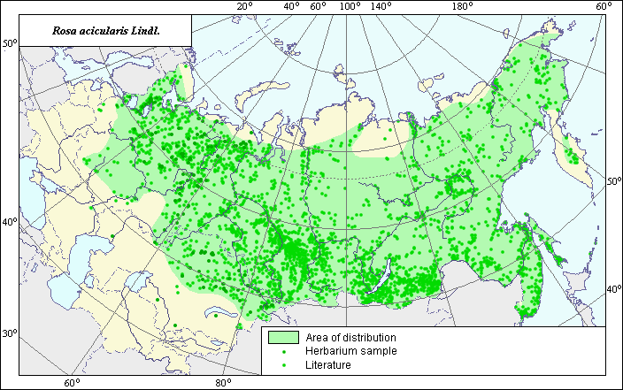 Object description Download GIS-layers
Authors:
The expert-botanist - Chuhina I.G., the GIS-Expert - Bagmet L.V.Date of creation:
14.12.2004Scale:
1:20 000 000.Accuracy of the map:
Map was created based on data from herbarium specimens and on maps having the following scale: 1:17 000 000-1:86 000 000.The projection:
"Alber's Equal Area Conic for Russia", 9, 1001, 7, 100, 0, 44, 68, 0, 0Basic contents:
Vector map. Area of species distribution is shown by polygons and actual location occurrence is shown by points.Accuracy of classifier:
Point data were obtained from literature sources and herbarium specimens. Polygons are based on literature sources, herbarium samples, and field surveys by the authors.Method of map production:
Published literature was reviewed, including Atlases, monographs and papers. Occurrence data were obtained from herbarium specimens, floras, monographs and papers. The data on distribution of the species were obtained from the VIR database of site coordinates of the species (N.I. Vavilov Institute, 1999) and published maps by the following authors: Sokolov et al. (1980), Schmidt (1983), Polozhij & Malyshev (1988), Kharkevich (1996), Koropachinskiy & Vstovskaya (2002), Hulten & Fries (1986). All borders of the area were determined according to Schmidt (1983). In the European part, the western border of the area was adjusted based on herbarium materials (N.I. Vavilov Institute, 1999).In Asia, the map boundaries were determined as follows: the northern border of the area according to Sokolov et al. (1980) and Polozhij & Malyshev (1988); the eastern border according to Kharkevich (1996) and Sokolov et al. (1980); the southern border of the area in Kazakhstan was constructed according to Sokolov et al. (1980) and herbarium materials. Occurence data of this species that extended beyond the border of the basic area were not included in final polygon because it is necessary make supplementary investigations. Data were compiled through scanning and geo-referencing to develop a composite vector map. The biologist, together with the GIS specialist, drew a new plant distribution area based on compiled data.
Reference citations:
Hulten E., Fries M. 1986. Atlas of North European Vascular Plants, North of the Tropic of Cancer. Konigstein: Koeltz Scientific Books. V. 1-3: 1172.Kharkevich S.S., ed. 1996. Vascular plants of the Soviet Far East. V. 8. Leningrad: Nauka. 233 p. (In Russian)
Koropachinskiy I.Yu., Vstovskaya T.N. 2002. Woody plants of the Asian part of Russia. Novosibirsk: Publishing House of SB RAS, Branch "Geo". 354 p. (In Russian)
N.I. Vavilov Institute, Herbarium Department, 1999. Information retrieval system: wild-growing relatives of cultural plants of Russia. STC Informregistr 0229905883, St. Petersburg, Russia.
Polozhij, A.V. & L.I. Malyshev, ed. 1988. Flora of Siberia. Rosaceae. V. 8. Novosibirsk: Nauka. Map #136. (In Russian)
Schmidt V.M., ed. 1983. Atlas of areas and resources of medicinal plants in the USSR. Moscow. 68-69 p. (In Russian)
Sokolov S.I., Svjaseva O.A., Kubli V.A. 1980. Areas of distribution of trees and shrubs in the USSR. V. 2. Leningrad: Nauka. Map #77. (In Russian)