
Relatives
The area of French rose (Rosa gallica L.)
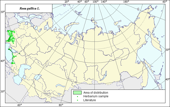 Object description Download GIS-layers
Authors:
The expert - botanist - Chukhina I.G., the GIS-expert - Sinitsyna T.A.Date of creation:
15.12.2004Scale:
1:20 000 000Accuracy of the map:
Map was created based on data from herbarium specimens and on maps having the following scale 1:13 000 000 - 1:25 000 000.The projection:
"Alber's Equal Area Conic for Russia", 9, 1001, 7, 100, 0, 44, 68, 0, 0Basic contents:
Vector map. Area of species distribution is shown by polygons, actual location occurrence is shown by points.Accuracy of classifier:
Point data were obtained from literature sources and herbarium specimens. Polygons are based on literature sources, herbarium samples, and field surveys by the authors.Method of map production:
Published literature was reviewed, including Atlases, monographs and papers. Occurrence data were obtained from herbarium specimens, floras, monographs and papers. The following sources were used to determine the map area: N.I. Vavilov Institute (1999), Grossgeim (1952), Sokolov et al. (1980). The species has a disjunctive area. In the Caucasus the northern border of the Black Sea-side of the area was drawn according to the map of Grossgeim (1952). Southern and eastern borders were drawn according to the map published by Sokolv et al. (1980). The Caspian parts of the area were constructed according to the map published by Grossgheim (1952) (northern Caucasus) and the maps published by Grossgheim (1952) and Sokolov et al. (1980) (Talysh). In the Crimea the northern border of the area was drawn according to the points published by Sokolov et al. (1980). South-western border of the area was constructed according to the herbarium specimens from the N.I. Vavilov Institute (1999). In the European part of the USSR the borders were constructed according to the map published by Sokolov et al. (1980) and was adjusted according to herbarium specimens. Data were compiled through scanning and geo-referencing to develop a composite vector map. The biologist, together with the GIS specialist, drew a new plant distribution area based on compiled data.Reference citations:
Grossgeim, A.A. 1952. Flora of the Caucasus. V. 5. Moscow-Leningrad: Publishing House of the USSR Academy of Sciences. Map #143. (In Russian)N.I. Vavilov Institute, Herbarium Department, 1999. Information retrieval system: wild-growing relatives of cultural plants of Russia. STC Informregistr 0229905883, St. Petersburg, Russia.
Sokolov S.I., Svjaseva O.A., Kubli V.A. 1980. Areas of distribution of trees and shrubs in the USSR. V. 2. Leningrad: Nauka. Map # 83A.
V.L. Komarov Botanical Institute [LE], St. Petersburg, Russia.