
Relatives
The area of Sakhalin raspberry (Rubus sachalinensis Levl.)
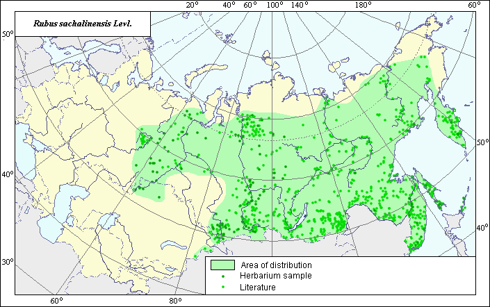 Object description Download GIS-layers
Authors:
The expert-botanist - Chukhina I.G., the GIS-Expert - Bagmet L.V.Date of creation:
19.04.2005Scale:
1:20 000 000.Accuracy of a map:
Map is based on data from herbarium specimans and on maps having the following scale: 1:11 100 000-1:50 000 000.The projection:
"Alber's Equal Area Conic for Russia", 9, 1001, 7, 100, 0, 44, 68, 0, 0Basic contents:
Map is a vector file consisting of polygons and points. Locations of species are represented by points, areas of possible distribution of species are represented by polygons.Accuracy of the qualifier:
Points represent locations of the species referenced in literature sources and from herbarium specimens. Polygons are based on generalized information from literature sources and herbarium specimens.Method of map contruction:
The data on distribution of the species were obtained from database of site coordinates of the species, in the Information Retrieval System "Wild-growing relatives of cultural plants of Russia" (NTC "Informregistr" #0229905883) and published maps of Svjazeva (1980), Kopanyova for "Atlas of areas and resources of medicinal plants in the USSR" (1983), Kurbatsky for "Flora of Siberia. Rosaceae" (1988), Klimov for "Vascular plants of the Soviet Far East" (1996), Koropachinskiy (2002), Baranova (2000).In Siberia and Ural north-western and south-western borders of area are constructed according to of Kurbatsky's maps (1988). Northern border in Siberia is carried on Kurbatsky's maps (1988) and Koropachinskiy's maps (2002), in the Far East - on Klimov's maps (1996) and Kopanyova's maps (1983). South-western border in Kazakhstan is constructed out on Svjazeva's data (1980). North-western and south-western borders of area are corrected on the basis of herbarium materials, stored in a database of the Information Retrieval System "Wild-growing relatives of cultural plants of Russia" (1999). Western border of area has been expanded on the basis of published Baranova's maps (2000) and herbarium materials.
References:
Atlas of medicinal plant habitats and resources in the USSR. 1983. Tolmachov's A.I. (ed.). Moscow, pp.140-141 (in Russian).Baranova, O.G. 2000. Map-schemes of distribution of rare plants between Vyatka and Kama rivers.Izhevsk: Publishing house "Udmurtia University ", p.127. (in Russian)
Flora of Siberia. Rosaceae. 1988. Polozhij A.V., Malyshev's L.I. (ed.). vol. 8. Novosibirsk: Nauka, map # 30. (in Russian).
Herbarium Specimans Komarov Botanical institute, Vavilov All Russian Institute of Plant Industry (WIR) (St.-Petersburg, Russia), Tomsk State University (Tomsk, Russia), Altai State University (Barnaul, Russia).
Information Retrieval System (IRS) "Wild relatives of cultural plants of Russia", 1999. N.I. Vavilov All Russian Institute of Plant Industry (WIR) (St.-Petersburg, Russia) NTC "Informregistr" № 0229905883.
Koropachinskiy, I.Yu., Vstovskaya, T.N. 2002. Woody plants of the Asian part of Russia. Novosibirsk: Publishing House of SB RAS, Branch "Geo", pp.369-370 (in Russian).
Sokolov, S.I., Svjaseva, O.A., Kubli, V.A. 1980. Areas of distribution of trees and shrubs in the USSR. vol.2. Leningrad: Nauka, map # 72(1).
Vascular plants of the Soviet Far East. 1996. Kharkevich's S.S. (ed.), vol. 8. Leningrad: Nauka, p.158 (in Russian).