
Relatives
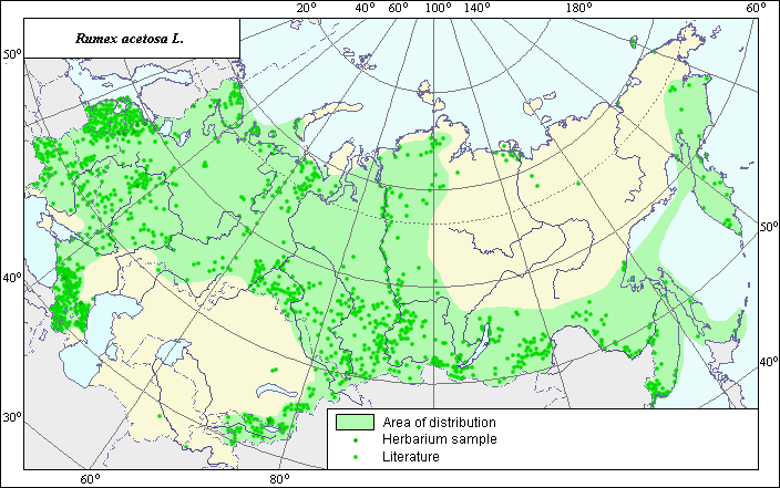
The area of Rumex acetosa L. (Sorrel)
 Object description Download GIS-layers
Authors:
The expert-botanist - T.N. Smekalova, the GIS-expert - G.V. Talovina.Date of creation:
26.11.2004Scale:
1:20 000 000Accuracy of map:
Map was created based on data from herbarium specimens and specified according to maps having the following scale: 1: 10 000 000 - 1: 80 000 000.The projection:
"Alber's Equal Area Conic for Russia", 9, 1001, 7, 100, 0, 44, 68, 0, 0Basic contents:
Vector map. Area of species distribution is shown by polygons and actual location occurrence is shown by points.Accuracy of classifier:
Point data were obtained from literature sources and herbarium specimens. Polygons are based on literature sources, herbarium samples, and field surveys by the authors.Method of map production:
Published literature was reviewed, including Atlases, monographs and papers. Occurrence data were obtained from herbarium specimens, floras, monographs and papers. The following sources were used to construct the map area: Schmidt (1990), Krasnoborov & Malyshev (1993), Malyshev & Peshkova (1979), Grosheim (1945), Hulten & Fries (1986), and the herbarium of the N.I. Vavilov Institute. The area consists of the range covering a significant part of the territory of the former USSR and separate points that were not included into its borders. The northern border of the area passes through the Arctic zone, in the south the species moves into the mountains of Pamir and Tian-Shan, bending around the zone of dry steppes, deserts and semi-deserts. In the Asian part of the former USSR the species occupies the territory of Western Siberia and the southern part of both Central and Eastern Siberia and the Far East. The points beyond the scope of range represent sites of the species in atypical conditions of growth (the species gravitates to meadows, rarefied woods and grasses of slopes and alpine zone of mountains). Data were compiled through scanning and geo-referencing to develop a composite vector map. The biologist, together with the GIS specialist, drew a new plant distribution area based on compiled data.Reference citations:
Cherepanov S.K. 1995. Plantae Vasculares Rossicae et Civitatum Collimitanearum (in limics USSR olim)[List of Vascular Plants of Russia]. St. Petersburg: Mir I Semia. 990 pp. (In Russian)Grossgeim, A.A. 1945. Flora of Caucasia. V. 3. Baku: Publishing House of Azerbaijan Acad. Science. 89 p., appendix. (In Russian)
Hulten E., Fries M. 1986. Atlas of North European Vascular Plants, North of the Tropic of Cancer. Konigstein. V. 1-3: 1172.
Komarov, V.L., ed. 1939. Flora USSR. V. 5. Moscow-Leningrad: Publishing House of Acad. Science. 451-452 p. (In Russian)
Krasnoborov, I.M. & L.I. Malyshev, ed. 1992. Flora of the Siberia. Salicaceae-Amaranthaceae. V. 5. Novosibirsk: Nauka. Map 117.
Malyshev, L.I. & G.A. Peshkova, ed. 1979. Flora of the Central Siberia. V. 1. Novosibirsk: Nauka. 278 p.
N.I. Vavilov Institute [WIR], St. Petersburg, Russia.
Schmidt V.M, ed. 1990. Areas of medicinal and related it plants of the USSR (the atlas). Leningrad: LGU. 37, 132-133 p.