
Relatives
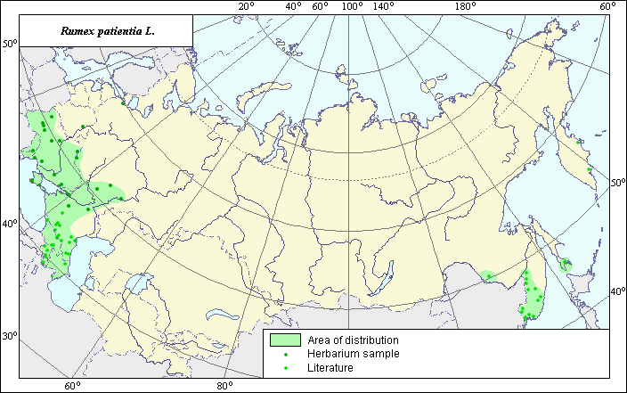
The area of Rumex patientia L. (Spinach sorrel)
 Object description Download GIS-layers
Authors:
The expert-botanist - T.N. Smekalova, the GIS-expert - G.V. Talovina.Date of creation:
16.12.2004Scale:
1:20 000 000Accuracy of the map:
Map was created based on data from herbarium specimens and specified according to maps having the following scale: 1: 10 000 000 - 1: 25 000 000.The projection:
"Alber's Equal Area Conic for Russia", 9, 1001, 7, 100, 0, 44, 68, 0, 0Basic contents:
Vector map. Area of species distribution is shown by polygons and actual location occurrence is shown by points.Accuracy of classifier:
Point data were obtained from literature sources and herbarium specimens. Light-colored points represent locations referenced in literature sources. Dark-colored points represent locations of species that were reported from herbarium samples. Polygons are based on literature sources, herbarium samples, and field surveys by the authors.Method of map production:
Published literature was reviewed, including Atlases, monographs and papers. Occurrence data were obtained from herbarium specimens, floras, monographs and papers. The following sources were used to determine the species area: herbaria of the V.L. Komarov Institute and Moscow State University, Grossheim (1945), Kharkevich (1989), Krasnoborov & Malyshev (1992). The area is presented as several polygons located both in European and in the Asian part of former USSR. The European range includes sites of the species in the south of the European part of the investigated territory. The East border of the contour reaches the coastal line of the Caspian Sea and up to the zone of deserts and semi-deserts; southern and western borders coincide with the frontier of the former USSR. The northern border of the contour unites sites of species in steppe and forest-steppe zones. In the Asian part of the investigated territory the area consists of several polygons. The basic Asian area includes sites in Ussuri river basin and in the south of Primorski Krai. The Sakhalin polygon includes sites of the species in the south of island Sakhalin, Zeya - Bureinsky - in Zeya and Bureya rivers basin. Points that were not included into borders of contours occur due to suitable habitat. Data were compiled through scanning and geo-referencing to develop a composite vector map. The biologist, together with the GIS specialist, drew a new plant distribution area based on compiled data.Reference citations:
Cherepanov S.K. 1995. Plantae Vasculares Rossicae et Civitatum Collimitanearum (in limics USSR olim)[List of Vascular Plants of Russia]. St. Petersburg: Mir I Semia. 990 pp. (In Russian)Grossheim, A.A. 1945. Flora of Caucasia. V. 3. Baku: Publishing House of Azerbaijan Acad. Science. 91 p., appendix. (In Russian)
Kharkevich S.S., ed. 1989. Vascular plants of the Soviet Far East. V. 4. Leningrad: Nauka. 34-35 p. (In Russian)
Komarov, V.L., ed. 1939. Flora USSR. V. 5. Moscow-Leningrad: Publishing House of Acad. Science. 464-465 p. (In Russian)
Krasnoborov, I.M. & L.I. Malyshev, ed. 1992. Flora of the Siberia. V. 5. Salicaceae-Amaranthaceae. Novosibirsk: Nauka. 102 p. (In Russian)
Moscow State University [MWG], St. Petersburg, Russia.
V.L. Komarov Botanical Institute [LE], St. Petersburg, Russia.