
Relatives
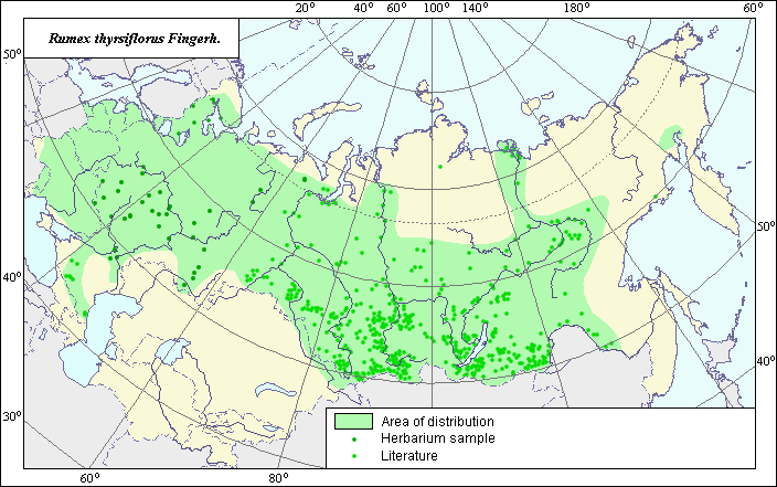
The area of Rumex thyrsiflorus Fingerh. - Pyramidal sorrel
 Object description Download GIS-layers
Authors:
The expert-botanist - T.N. Smekalova, the GIS-expert - G.V. Talovina.Date of creation:
09.12.2004Scale:
1:20 000 000Accuracy of map:
Map was created based on data from herbarium specimens and specified on maps having the following scale - 1:10 000 000 - 1:80 000 000.The projection:
"Alber's Equal Area Conic for Russia", 9, 1001, 7, 100, 0, 44, 68, 0, 0Basic contents:
Vector map. Area of species distribution is shown by polygons and actual location occurrence is shown by points.Accuracy of classifier:
Point data were obtained from literature sources and herbarium specimens.Light-colored points represent locations referenced in literature sources. Dark-colored points represent locations of the species that were reported from herbarium samples. Polygons are based on literature sources, herbarium samples, and field surveys by the authors.
Method of map production:
Published literature was reviewed, including Atlases, monographs and papers. Occurrence data were obtained from herbarium specimens, floras, monographs and papers. The following sources were used to construct the species area: Moscow State University herbarium, Krasnoborov & Malyshev (1992), Malyshev & Peshkova (1979), Grossgeim (1945), Kharkevitch (1989), Hulten & Fries (1986). The area is represented as the basic range, a small range in the south of Eastern Siberia and separate points beyond the scope of the polygon. The species is Eurasian and the basic polygon of its area occupies most of both the European and Asian parts of the former USSR, except for desert and semi-desert territories. In the south of the western part of the polygon the contour includes the territory of Ciscaucasia and southern Ural. The Asian part of the polygon includes the northern part of western Siberia, a southern part of Eastern Siberia, the western part of Eastern Siberia and the Zeya-Bureinsky area of the Far East. The western and southeast borders of the range coincide with the frontier of the former USSR, northern, southwest and east borders which were constructed according to the generalization of the available data on species distribution. The points which were not included into the borders of the contour represent isolated suitable habitat for the species. Data were compiled through scanning and geo-referencing to develop a composite vector map. The biologist, together with the GIS specialist, drew a new plant distribution area based on compiled data.Reference citations:
Cherepanov S.K. 1995. Plantae Vasculares Rossicae et Civitatum Collimitanearum (in limics USSR olim)[List of Vascular Plants of Russia]. St. Petersburg: Mir I Semia. 990 pp. (In Russian)Grossgeim, A.A. 1945. Flora of Caucasia. V. 3. Baku: Publishing House of Azerbaijan Acad. Science. 89 p., appendix. (In Russian)
Hulten E., Fries M. 1986. Atlas of North European Vascular Plants, North of the Tropic of Cancer. Konigstein. V. 1-3: 1172.
Kharkevitch S.S., ed. 1989. Vascular plants of the Soviet Far East. V. 5. Leningrad: Nauka. 50-51 p. (In Russian)
Komarov, V.L., ed. 1939. Flora USSR. V. 5. Moscow-Leningrad: Publishing House of Acad. Science. 451-452 p. (In Russian)
Krasnoborov, I.M. & L.I. Malyshev, ed. 1992. Flora of the Siberia. Salicaceae-Amaranthaceae. V. 5. Novosibirsk: Nauka. 247 p. (In Russian)
Malyshev, L.I. & G.A. Peshkova, ed. 1979. Flora of the Central Siberia. V. 1. Novosibirsk: Nauka. 280 p. (In Russian)
Moscow State University [MWG], St. Petersburg, Russia.