
Relatives
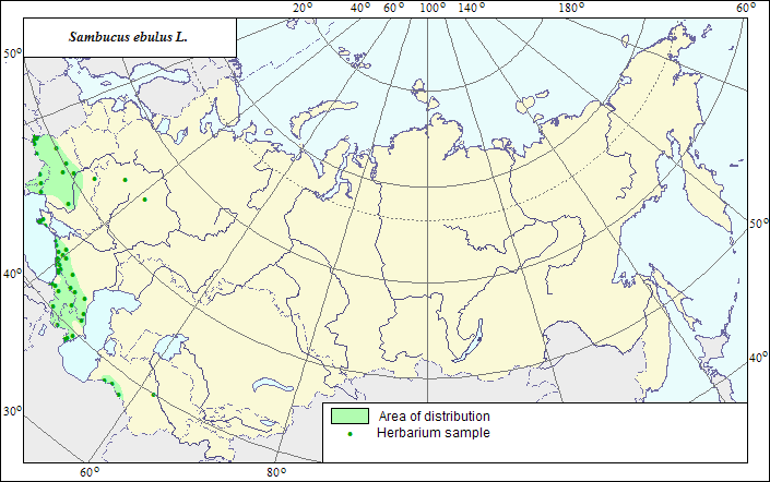
Range of distribution of Sambucus ebulus L. - Dwarf Elder, Danewort.
 Object description Download GIS-layers
Authors:
The expert-botanist - T.N.Smekalova,the GIS expert - R.S.Ushakova.
Date of creation:
18.04.2007Scale:
1:20 000 000.Accuracy of the map:
The map is based on data of a 1:10 000 000 scale map, specified according to herbarium materials.Projection:
"Albers Equal-Area Conic Projection for USSR", 9, 1001, 7, 100, 0, 44, 68, 0, 0Basic contents:
The map is a vector file consisting of a polygon and dots. Point localities of the species are represented by dots, the area of possible species distribution is represented by the polygon.Accuracy of the qualifier:
Dark dots represent information on the species localities from herbarium specimens, the rest (light) dots represent data from published sources; the polygon is based on generalized information from published sources and herbarium specimens.Method of the map construction:
The main part of the species range is situated in the Central and Atlantic Europe, Mediterranean, reaching northern Iran in the south. In the former USSR, the species is distributed in the southern European part, Crimea, Caucasus and Central Asia (mountain Turkmenistan, Kopet-Dagh). The range consists of 4 polygons: European, Crimean, Caucasian and Central Asian. The Central Asian polygon is constructed by generalization of factual data (LE and WIR Herbaria) on the species localities in Kopet-Dagh. The southern border of this polygon is limited by the former state border of the USSR, in its northern part the species distribution is limited by deserts. The northern border of the Caucasian polygon is limited by steppe zone, in the west and east the species distribution is limited by the Black and Caspian Seas. The southern border of the polygon coincides with the former state border of the USSR. In the Crimea, the species occurs in the southern, mountain part of Crimean Peninsula. The European polygon is constructed after both factual (herbarium), and published data (Shishkin, 1958; Barbarich et al., 1965; Geideman, 1975; and others). Barbarich et al. (1965) cite the species to occur in the Carpathians, Polesia and Central Ukraine, where it takes the forest-steppe area in the Dnieper right-side areas. In the Dnieper right-side areas, the species occurs solitarily. Geideman (1975) specifies the regions of the species distribution in Moldova. The borders of the European polygon were drawn according to the cited sources and herbaria. Single dots beyond the polygon borders indicate alien localities of the species.References:
Barbarich AI., Bradis EM., Visyulina OD., Volodchenko VS. 1965. Manual of plants of Ukraine. 2nd ed. Kiev: Urozhay. P.638. (In Ukrainian).Geideman TS. 1975. Manual of higher plants of Moldavian Soviet Socialist Republic. 2nd ed. Kishinev: Shtiintsa. P.455. (In Russian).
Shishkin BK., ed. 1958. Flora URSS. V.23. P.427-428. (In Russian).
Cherepanov SK. 1995. Vascular plants of Russia and adjacent states (the former USSR). St.Petersburg. 990 p. (In Russian).
Herbarium specimens of V.L.Komarov Botanical Institute [LE], St.Petersburg, Russia.
Rights and copyrights:
The copyrights of the map and descriptions are held by their authors.The copyright of the image is held by R.S.Ushakova (WIR).