
Relatives
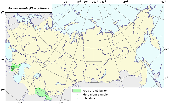
Area of weed-field Rye (Secale segetale) .
 Object description Download GIS-layers
Authors:
Expert on object - L.L.MalyshevGIS-expert - L.L.Malyshev.
Date of creation:
2.20.2007Scale:
1:20000000.Accuracy of a map:
It is created on materials of maps of scale 1:2000000-1:11250000.Projection:
"Equal of Albers to the USSR", 9, 1001, 7, 100, 0, 44, 68, 0, 0The basic contents:
Vector map from 1 base and 3 thematic layers. The area of a species is presented by range and points.Accuracy of the qualifier:
Points present the information on sites of a species according to herbariums (1) and references (2), by range - the generalized information on distribution of a species.Technique of drawing up of a map:
For a basis of a map of an area the coordinates received according to herbariums, and the published maps from monographies "Flora of Caucasus" (1939), "Cultural flora of the USSR" (1989) have been taken.In territory of the former USSR the species meets in Transcaucasia and in foothill areas of Central Asia. N.I.Tsvelev (1976) allocates in independent species Secale vavilovii and Secale segetale and includes in structure of the last species S.ancestrale, S.afganicum and S.dighoricum (as subspecies). V.D.Kobyljansky (1989) unites Secale segetale and S.vavilovii in subspecies of Secale cereale.
Sources of data:
Grossheim A.A. Flora of Caucasus. V.2. Polypodiaceae - Gramineae. - Baku: Publishing house AzFaN, 1939. - 587 p.Cultural flora of the USSR. V.2, p.1. A rye / Ed. V.D.Kobyljanskiy. - L.: Agropromizdat, 1989. - 368 p.
The rights and copyrights:
All the rights to a map and descriptions belong to its author.Photos - © Dzjubenko E.A.