
Relatives
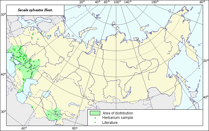
Area of wild Rye (Secale sylvestre) .
 Object description Download GIS-layers
Authors:
Expert on object - L.L.Malyshev GIS-expert - L.L.Malyshev.Date of creation:
1/20/2007Scale:
1:20000000.Accuracy of a map:
It is created on materials of maps of scale 1:2000000-1:11250000.Projection:
"Equal of Albers to the USSR", 9, 1001, 7, 100, 0, 44, 68, 0, 0The basic contents:
Vector map from 1 base and 3 thematic layers. The area of a species is presented by range and points.Accuracy of the qualifier:
Points present the information on sites of a species according to herbarium LE (1) and references (2), by range - the generalized information on distribution of a species.Technique of drawing up of a map:
For a basis of a map of an area the coordinates received according to herbariums, and the published maps from monographies "Cereals of Ukraine" (1997), "Flora of Caucasus" (1939), "Cultural flora of the USSR" (1989) have been taken.The area of a species in territory of the Former USSR covers steppe areas of the European part of the former USSR, East Transcaucasia and through Northern Iran and Afghanistan comes into foothill areas of Central Asia - in Kopet-Dag and Tajikistan. Most likely the wild rye does not meet on a greater part of Kazakhstan and in sandy deserts Kara Kum and Kizil Kum.
Sources of data:
Grossheim A.A. Flora of Caucasus. V.2. Polypodiaceae - Gramineae. - Baku: Publishing house AzFaN, 1939. - 587 p.Cereals of Ukraine. - Kiev: "Naukova Dumka", 1977. - 518 p.
Cultural flora of the USSR. V.2, p.1. A rye / Ed. V.D.Kobyljanskiy. - L.: Agropromizdat, 1989. - 368 p.
The rights and copyrights:
All the rights to a map and descriptions belong to its author.Photos - © Dzjubenko E.A.