
Relatives
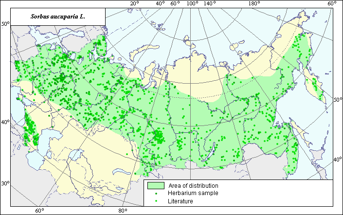
The area of European mountain ash (Sorbus aucuparia L.)
 Object description Download GIS-layers
Authors:
The expert-botanist - Chukhina I.G.,the GIS-Expert - Ozerskaya T.M.
Date of creation:
22.04.2005Scale:
1:20 000 000.Accuracy of a map:
Map is based on data from herbarium specimans and on maps having the following scale: 1:17 000 000-1:50 000 000.The projection:
"Alber's Equal Area Conic for Russia", 9, 1001, 7, 100, 0, 44, 68, 0, 0Basic contents:
Map is a vector file consisting of polygons and points. Locations of species are represented by points, areas of species are represented by polygons.Accuracy of the qualifier:
Points represent locations of the species referenced in literature sources and from herbarium specimens. Polygons are based on generalized information from literature sources and herbarium specimens.Method of map contruction:
The species Sorbus aucuparia is regarded widely in this work, i. e. it includes some forms which often are regarding as separate species (S. sibirica Hedl., S. caucasigena Kom.). The data on distribution of the species were obtained from database of site coordinates of the species, in the Information Retrieval System "Wild-growing relatives of cultural plants of Russia" (NTC "Informregistr" #0229905883, 1999) and published maps of A.A. Grossgeim (1952), E.V. Baranova for " Atlas of medicinal plant habitats and resources in the USSR" (1983), P.B. Klimov for "Vascular plants of the Soviet Far East" (1996), I.Yu. Koropachinskiy (2002), Hulten (1986) and published maps of O. A. Svjazeva (1980). Mainly, all borders of the area are carried according to E.V. Baranova (1983). In the Siberian part, the northern border of the area is modified according to the herbarium materials, stored in a database of the Information Retrieval System "Wild-growing relatives of cultural plants of Russia" (1999), the south-western border is modified according to the data of E. Hulten (1986), O. A. Svjazeva (1980) and herbarium materials. On the Far East, the border of the area is constructed on the basis of P.B. Klimov.s (1996) data. The Caucasian part of the area is constructed according to A.A. Grossgeim.s data and herbarium material, the Crimean part is constructed according to herbarium material. Some finding points of this species separated from the main part of the area are not included into polygon because they need an additional research to test a possibility their originating from escaped culture plants.References:
Atlas of medicinal plant habitats and resources in the USSR. 1983. Tolmachov's A.I. (ed.). Moscow, pp.34-35, 52-53 (in Russian).Grossgeim, A.A. 1952. Flora of the Caucasus, vol. 5. Moscow/Leningrad: Publishing House of the USSR Academy of Sciences, map # 24. (in Russian).
Herbarium N.I. Vavilov All-Russian Institute of Plant Industry (WIR) (St.-Petersburg, Russia), Komarov Botanical Institute (LE) (Saint-Petersburg), The Biological Faculty of the Lomonosov State University of Moscow (MW).
Hulten, E. & Fries, M. 1986. Atlas of North European vascular plants: north of the Tropic of Cancer. I-III. - Koeltz Scientific Books, Konigstein.
Information Retrieval System (IRS) "Wild relatives of cultural plants of Russia", 1999. N.I. Vavilov All Russian Institute of Plant Industry (WIR) (St.-Petersburg, Russia) NTC "Informregistr" № 0229905883.
Koropachinskiy, I.Yu., Vstovskaya, T.N. 2002. Woody plants of the Asian part of Russia. Novosibirsk: Publishing House of SB RAS, Branch "Geo", p.299 (in Russian).
Sokolov, S.I., Svjaseva, O.A., Kubli, V.A. 1980. Areas of distribution of trees and shrubs in the USSR. vol.2. Leningrad: Nauka, p.62 (in Russian).
Vascular plants of the Soviet Far East. 1996. Kharkevich's S.S. (ed.), vol. 8. Leningrad: Nauka, p.142. (in Russian).
Right and copyright:
Copyright on this map and description belongs to its authors;copyright for picture belongs Chukhina I.G.