
Relatives
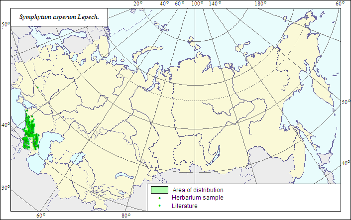
Range of distribution of Rough Comfrey (Symphytum asperum Lepech.).
 Object description Download GIS-layers
Authors:
The expert-botanists - N.I.Dzyubenko, E.A.Dzyubenko.The GIS expert - A.N.Dzyubenko.
Date of creation:
17.09.2007Scale:
1:20 000 000.Accuracy of the map:
The map is based on data of 1:13 000 000 - 1:60 000 000 scale maps, specified according to herbarium materials.Projection:
"Albers Equal-Area Conic Projection for USSR", 9, 1001, 7, 100, 0, 44, 68, 0, 0Basic contents:
The map is a vector file consisting of 1 basic and 2 subject layers. The species range is represented by a polygon and dots.Accuracy of the qualifier:
The dots represent information on the species localities: 1 - reliable data according to herbarium and published sources; the polygon (1) - generalized information on the species distribution from published sources and herbarium specimens.Method of the map construction:
The data from the herbarium materials of LE and published maps of the range (Meusel et al., 1965; Grossheim, 1967) were used for constructing the range of Symphytum asperum. The range consists of one polygon and dots. The main range is restricted by the Caucasus region; due to introduction; however, the records of the species in Ukraine and Northwestern Russia are not impossible.References:
Galushko AI. 1980. Flora of the North Caucasus: Handbook. V.2. 352 p. (In Russian).Grossheim AA. 1967. Flora of Caucasus. 2nd ed. V.7. P.263-264. (In Russian).
Medvedev PF., Smetannikova AI. 1981. Forage plants of European part of the USSR. Leningrad: Kolos. 336 p. (In Russian).
Meusel H. et al. 1965. Vergleichende Chorologie der Zentraleuropaischen Flora. Jena. 583 S.
Herbarium specimens of V.L.Komarov Botanical Institute [LE], St.Petersburg, Russia.
Rights and copyrights:
The copyrights of the map and descriptions are held by their authors.The copyright of the photo is held by E.A.Dzyubenko.