
Relatives
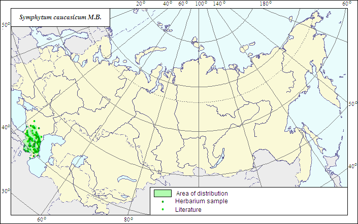
Range of distribution of Caucasian Comfrey (Symphytum caucasicum M.B.).
 Object description Download GIS-layers
Authors:
The expert-botanists - N.I.Dzyubenko, E.A.Dzyubenko.The GIS expert - A.N.Dzyubenko.
Date of creation:
17.09.2007Scale:
1:20 000 000.Accuracy of the map:
The map is based on data of 1:13 000 000 - 1:60 000 000 scale maps, specified according to herbarium materials.Projection:
"Albers Equal-Area Conic Projection for USSR", 9, 1001, 7, 100, 0, 44, 68, 0, 0Basic contents:
The map is a vector file consisting of 1 basic and 2 subject layers. The species range is represented by a polygon and dots.Accuracy of the qualifier:
The dots represent information on the species localities: 1 - reliable data according to herbarium and published sources; the polygon (1) - generalized information on the species distribution from published sources and herbarium specimens.Method of the map construction:
The data from the herbarium materials of LE and published maps of the range (Meusel et al., 1965; Grossheim, 1967) were used for constructing the range of Symphytum caucasicum. The data of the maps had no disagreements with each other. We have extended the range borders up to the Black Sea coast due to available herbarium collections and data in "Flora of Caucasus" (Grossheim, 1952). The final range of the speices consists of one polygon and dots.References:
Grossheim AA. 1967. Flora of Caucasus. 2nd ed. V.7. P.263-264. (In Russian).Medvedev PF., Smetannikova AI. 1981. Forage plants of European part of the USSR. Leningrad: Kolos. 336 p. (In Russian).
Meusel H. et al. 1965. Vergleichende Chorologie der Zentraleuropaischen Flora. Jena. 583 S.
Herbarium specimens of V.L.Komarov Botanical Institute [LE], St.Petersburg, Russia.
Rights and copyrights:
The copyrights of the map and descriptions are held by their authors.The copyright of the photo is held by E.A.Dzyubenko.