
Relatives
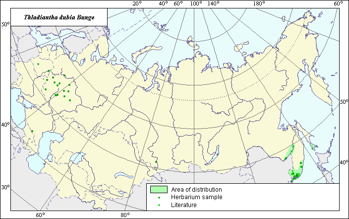
The area of Thladiantha dubia Bunge (Thladiantha doubtful) .
 Object description Download GIS-layers
Authors:
The expert-botanist - T.N. Smekalova, the GIS-expert - G.V. Talovina.Date of creation:
03.11.2004Scale:
1:20 000 000Accuracy of the map:
Map was created based on data from herbarium specimens and specified on maps having the following scale: 1: 25000 000.The projection:
"Alber's Equal Area Conic for Russia", 9, 1001, 7, 100, 0, 44, 68, 0, 0Basic contents:
Vector map. Area of species distribution is shown by polygons and actual location occurrence is shown by points.Accuracy of classifier:
Point data were obtained from literature sources and herbarium specimens. Light-colored points represent locations referenced in literature sources. Dark-colored points represent locations of the species that were reported from herbarium samples. Polygons are based on literature sources, herbarium samples, and field surveys by the authors.Method of map production:
Published literature was reviewed, including Atlases, monographs and papers. Occurrence data were obtained from herbarium specimens, floras, monographs and papers. The following sources were used to determine the map area: Kharkevich (1987), V.L. Komarov Botanical Institute herbarium, N.I. Vavilov Institute of Plant Industry herbarium, Moscow State University herbarium. The species originated from the territory of Northeast China; some points of its sites are located in the territory of the Primorski Krai and Sakhalin which characterize the northern-east edge of the natural area of the species. The area for the territory of the former USSR has a disjunctive character and it is presented as three ranges based on the work of Kharkevich (1987) and the information from herbarium collections. The Northern range covers the middle part of the Amur River area. The Sakhalinian part of the area is situated in the southern part of Sakhalin. The Southern area includes a joint set of sites which are distributed in the north-east part of the natural area. A set of points located in the territory of the European part of the former USSR represents a secondary area of the species within the investigated territory. The species is willingly cultivated and easily escapes cultivation. Within the limits of the European part of the former USSR it reaches Tver and Nizhni Novgorod latitude in the north and can be found as a weed plant in gardens, plots and near habitation. Data were compiled through scanning and geo-referencing to develop a composite vector map. The biologist, together with the GIS specialist, drew a new plant distribution area based on compiled data.Reference citations:
Cherepanov S.K. 1995. Plantae Vasculares Rossicae et Civitatum Collimitanearum (in limics USSR olim)[List of Vascular Plants of Russia]. St. Petersburg: Mir I Semia. 990 pp. (In Russian)Kharkevich S.S., ed. 1987. Vascular plants of the Soviet Far East. V. 3. Leningrad: Nauka. 132 p. (In Russian)
Moscow State University [MWG], Moscow, Russia.
N.I. Vavilov Institute of Plant Industry [WIR], St. Petersburg, Russia.
Shishkin, B.K. & E.G. Bobrov, ed. 1957. Flora USSR. V. 24. Moscow-Leningrad: Publishing House of Acad. Science. 95-97 p. (In Russian)
Tsvelev N.N. 2000. Manual of the vascular plants of Russia (Leningrad, Pskov and Novgorod district). St. Petersburg: Publishing House of SPHFA. 781 p. (In Russian)
V.L. Komarov Botanical Institute [LE], St. Petersburg, Russia.