
Relatives
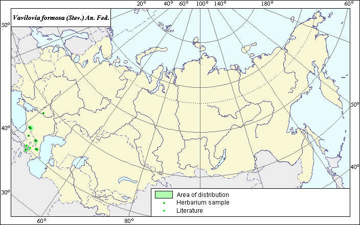
Area of Vavilovia (Vavilovia formosa ).
 Object description Download GIS-layers
Authors:
The experts - Dzyubenko N. I., E. A. Dzyubenko.The GIS-Expert - Dzyubenko A. N.
Date of creation:
17.06.2004Scale:
1:20 000 000.Exactness of a map:
The map was created using maps that had the following scale 1:10 000 000.The projection:
"Alber's Equal Area Conic for Russia", 9, 1001, 7, 100, 0, 44, 68, 0, 0Basic contents:
Map is a vector file consisting of polygons and points. Locations of species are represented by points, area of possible distribution of species are represented by polygons.Exactness of classifier:
Light-colored points are locations referenced in literature sources. Dark-colored points are locations of the species that were as reported from created database VIR (N.I.Vavilov All-Russian Research Institute of Plant Industry) and BIN (the Komorov Institute of Botany).Polygons are based on literature sources, herbarium samples, political boundaries and ecological description.Method of map construction:
Location and area of distribution The area of aof the species is based on a rezults of published maps and analysis of materials from the Vavilov Institute. Literature used included: The basis of this area are: the map of Onobrychis miniata distribution from Grossheim A. A. (1952) and database of VIR and BIN.Sources of the data:
Grossheim A. A. Vavilovia genus. Flora of the Caucasus. - M. - L.: AN USSR, 1952. - V.5.- p. 414 - 416.Created database of the VIR materials (N. I. Vavilov Allrussian Institute of Plant Industry)and BIN materials (the Komorov Institute of Botany).
Rights and copyrights:
Copyright on the map and descriptions belong to its authors;© Photo Dzyubenko N. I.