
Relatives
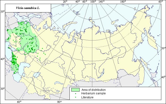
Area of danzig vetch (Vicia cassubica L.).
 Object description Download GIS-layers
Authors:
The experts - Dzyubenko N. I., E. A. Dzyubenko.The GIS-Expert - Dzyubenko A. N.
Date of creation:
17.09.2004Scale:
1:20 000 000.Exactness of a map:
The map was created using maps that had the following scale 1:10 000-1:80 000 000.The projection:
"Alber's Equal Area Conic for Russia", 9, 1001, 7, 100, 0, 44, 68, 0, 0Basic contents:
Map is a vector file consisting of polygons and points. Locations of species are represented by points, area of possible distribution of species are represented by polygons.Exactness of classifier:
Light-colored points are locations referenced in literature sources. Dark-colored points are locations of the species that were as reported from created database VIR (N.I.Vavilov All-Russian Research Institute of Plant Industry) and BIN (the Komorov Institute of Botany). Polygons are based on literature sources, herbarium samples, political boundaries and ecological description.Method of map construction:
For construction of the area of Vicia cassubica the published maps of areas (Grossheim, 1952; Meusel Y. und and., 1965; Hulten, Eric and Magnus Fries, 1986) and herbaria data (Komarov Botanical Institute (BIN), N.I. Vavilov All Russian Institute of Plant Industry (VIR), St.-Petersburg) were used.Our point of view for distribution of species on the territory of Russia and the adjacent states partly coincides with understanding of the area of species by Meusel Y. und and. (1965) and Hulten, Eric and Magnus Fries (1986) and by authors of .Flora of European part of the USSR (1987).. The definition of area border is based on all available data which have no significant contradictions. The area has disjunctive character and consists of three polygons and separate points.The greatest polygon occupies territory of European part of former USSR (all regions except northern and southern). The Crimean polygon also covers a southern, mountain part of the Crimean peninsula. Within the limits of the Caucasian polygon, distribution of a species from a south-east and a south-west is limited by Black and Caspian Seas and frontier. The points, which were not included into borders of areas represent the sites of the secondary origin of the species. Polygon on Hulten at all. (1986) on territory of Turkmenistan not confirmed by our and other literary information (Nikitin , Geldikhanov , 1988).Sources of the data:
Flora of the European part of the USSR. 1987. Phyodorov A. A. (ed.). Vol. VI. - 254 pp. (in Russian).Grossheim A. A. 1952. Genus Vicia. Flora of the Caucasus. - M. - L.: Academy of Science of the USSR, Vol. V. - p. 380 - 398. (in Russian).
Hulten, Eric and Magnus Fries. 1986. Atlas of north European vascular plants north of the Tropic of Cancer.
Meusel Y. und and.1965. Vergleichende Chorologie der Zentraleuropischen Flora. Jena:, - 583 s.
Created database of the VIR materials (N. I. Vavilov Allrussian Institute of Plant Industry) and BIN materials (the Komorov Institute of Botany).
Rights and copyrights:
Copyright on the map and descriptions belong to its authors;Copyright on the photos belong to Dzyubenko N. I.