
Relatives
Area common vetch (Vicia sativa L.).
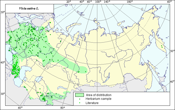 Object description Download GIS-layers
Authors:
The experts - Dzyubenko N.I., E.A. Dzyubenko.The GIS-Expert - Dzyubenko A.N.
Date of creation:
17.09.2004Scale:
1:20000000Accuracy of map:
The map was created based on maps that had the following scale: 1:10000000.The projection:
"Alber's Equal Area Conic for Russia", 9, 1001, 7, 100, 0, 44, 68, 0, 0Basic contents:
Vector map. Area of species distribution is shown by polygons and actual location occurrence is shown by points.Accuracy of classifier:
Point data were obtained from literature sources and herbarium specimens. Light-colored points are locations referenced in literature sources. Dark-colored points are locations of the species that were reported from created database of VIR (N.I. Vavilov Institute) and the V.L. Komarov Botanical Institute of Botany.Polygons are based on literature sources, herbarium samples, and field surveys by the authors.
Method of map production:
Published literature was reviewed, including Atlases, monographs and papers. Occurrence data were obtained from herbarium specimens, floras, monographs and papers. The following herbaria and literature sources were used to determined the species area: N.I. Vavilov Institute (2003), V.L. Komarov Institute, Grossgheim (1952). Data were then compiled through scanning and geo-referencing to develop a composite vector map. The biologist, together with the GIS specialist, drew a new plant distribution area based on compiled data.Reference citations:
Grossheim, A.A. 1952. Genus Vicia. Flora of the Caucasus. V. 5. Moscow-Leningrad: Academy of Science of the USSR. 380-398 p. (In Russian)N.I. Vavilov Institute, Herbarium Department, 2003. Database of geographic coordinates (in house), St. Petersburg, Russia.
V.L. Komarov Botanical Institute [LE], St. Petersburg, Russia.