
Relatives
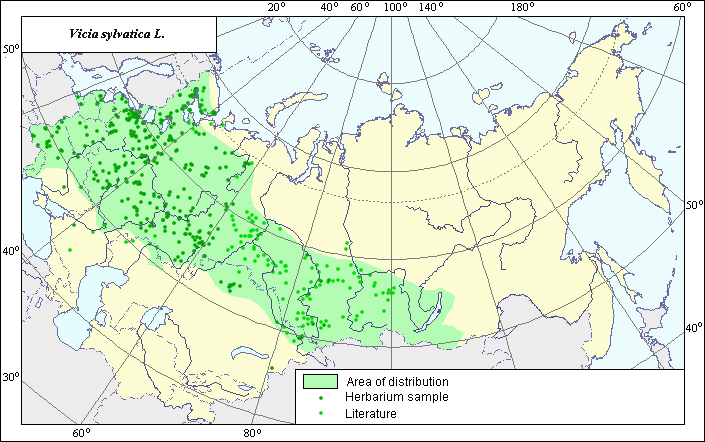
Area of wood vetch (Vicia sylvatica L.).
 Object description Download GIS-layers
Authors:
The experts - Dzyubenko N. I., E. A. Dzyubenko.The GIS-Expert - Dzyubenko A. N.
Date of creation:
17.05.2005.Scale:
1:20 000 000.Exactness of a map:
The map was created using maps that had the following scale 1:30 000-1:80 000 000.The projection:
"Alber's Equal Area Conic for Russia", 9, 1001, 7, 100, 0, 44, 68, 0, 0Basic contents:
Map is a vector file consisting of polygons and points. Locations of species are represented by points, area of possible distribution of species are represented by polygons.Exactness of classifier:
Light-colored points are locations referenced in literature sources. Dark-colored points are locations of the species that were as reported from created database VIR (N.I.Vavilov All-Russian Research Institute of Plant Industry) and BIN (the Komorov Institute of Botany). Polygons are based on literature sources, herbarium samples, political boundaries and ecological description.Method of map construction:
For construction of the area of Vicia sylvatica the published maps of areas (Flora of Siberia, 1994; Flora of Central Siberia,1979; Hulten, Eric and Magnus Fries, 1986;) and herbaria data (Komarov Botanical Institute (BIN) and N.I. Vavilov All Russian Institute of Plant Industry (VIR), St.-Petersburg) were used. The presented area created by data generalization is the polygon (green line) and separate points. The polygon occupies the forest zone of European and Siberian territory of former USSR and north-eastern part of Kazakhstan. The northern border of the polygon coincides with the border of taiga zone. The more northern borders (in compare of area borders by Hulten, Eric and Magnus Fries, 1986) are based on the numerous BIN herbaria data. The eastern part of the area is based on the published maps (Flora of Siberia, 1994; Flora of Central Siberia, 1979). The southern border of the polygon coincides with the border of wood-steppe zone. The polygon includes also the territory of Moldova on the base of literary data (Flora of the European part of the USSR. 1987).In the definition of the border of the area we took into account biological and ecological peculiarities of the species and all available literary data (Field Guide of Plants of Central Asia, 1981; Flora of cultivated plants, 1999; Flora of Kazakhstan, 1961; Flora of the USSR, 1948; Flora of the European part of the USSR. 1987) which had no significant contradictions. The points, which were not included into borders of contours, represent single sites of the species.Sources of the data:
Flora of Siberia. 1994. Polozhiy A.B., Malyshev L.I., (ed.). - Novosibirsk: Nauka, Vol. 9. - 280 pp. (in Russian).Flora of Central Siberia. 1979. Malyshev L.I., Peshkova G. A. (ed.). Novosibirsk: Nauka, Vol. II, 506 pp. (in Russian).
Hulten, Eric and Magnus Fries. 1986. Atlas of north European vascular plants north of the Tropic of Cancer.
Created database of the VIR materials (N. I. Vavilov Allrussian Institute of Plant Industry) and BIN materials (the Komorov Institute of Botany).
Rights and copyrights:
Copyright on the map and descriptions belong to its authors;Copyright on the photos belong to Dzyubenko N. I.