
Weeds
Area and zones of harmfulness of Bidens tripartita L.
 Object description Download GIS-layers
Authors:
Specialist-biologist - I.N. NadtochiiGIS-specialist - I.A. Budrevskaya
Date of creation:
30.11.2003.Scale:
1:20,000,000.Accuracy of map:
Created using information taken from published literature and maps of scale 1:10,000,000-1:80,000,000.Projection:
"Alber's Equal Area Conic for the USSR", 9, 1001, 7, 100, 0, 44, 68, 0, 0.Basic content:
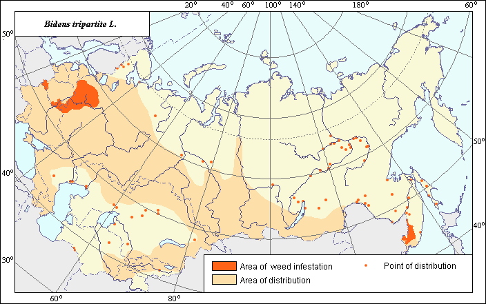
Vector map. Area is shown by polygon (the main distribution) and by points (sporadic distribution). Zone of harmfulness is shown by polygon.Accuracy of classifier:
Area and zones of harm have been compiled by analyzing published cartographical materials and literature. Maps of Bidens tripartita distribution developed by Chikova (1983) and Hulten et al. (1986) were used for drawing the area. Map by Chikova (1983) is more detailed and extensive and therefore is used as a base map. Corrections have been made in the south of European FSU, in Siberia and in the Far East. The main area has been narrowed and depicted as sporadic distribution, as records of the weed are sparse or located along the river Lena and its tributaries (in Siberia). The zone of harm is based on literature data by Kozlovskaya & Simonovich (1966); Korovina (1982); Oksenyuk (1982) and Shatokhin & Birkbaum (1982) with boundaries corresponding to the map of arable lands.Method of map production:
Published literature was reviewed, including atlases, monographs and papers. Occurrence data were obtained from herbarium specimens, floras, monographs and papers. Data were then compiled through scanning and geo-referencing to develop a composite vector map. The biologist, together with the GIS specialist, drew a composite weed distribution area based on compiled data.Reference citations:
Chikov P.S., ed. 1983. Atlas of medicine plants areas and resources of the USSR. Moscow. 56-57 pp. (In Russian)Gaidashakin V.I., Makashvilli A.K, Yabrova V.S., Yaroshenko P.D. 1936. Weed plants of wet subtropics of the USSR and their control. Sukhumi. N.31: 136. (In Russian)
Hulten E., Fries M. 1986. Atlas of North European Vascular Plants, North of the Tropic of Cancer: Konigstein. V. 1-3: 1172.
Koroljeva, I.E., Vilchevskaya, E.V., Ruhovich, D.I. 2003. Digital Arable Land Map. Laboratory of Soil Information of the Dokuchaev Soil Institute, Moscow.
Korovina O.N., ed. 1982. Weed plants of the Non-Chernozem Zone of Russia. Katalog mirovoi kollektsii VIR. Issue 338. Leningrad: VIR. 117 pp. (In Russian)
Kozlovskaya N.V., Simonovich L.G. 1966. Features of weed distribution on turfy-podzol soils of Polesye region. In: Geobotanical Research. Minsk: Nauka i tekhnika. P. 56-64 (In Russian)
Oksenyuk Yu.F. 1982. Weed control in orchards, berry gardens and vineyards in the Far East. In: Bor`ba s sornoi rastitel`nost`yu na Dal`nem Vostoke. Novosibirsk. 71-74 pp. (In Russian)
Shatokhin A.I., Birkbaum F.N. 1982. Weed control in the Khabarovsk Territory. In: Bor`ba s sornoi rastitel`nost`yu na Dal`nem Vostoke. Novosibirsk. 94-96 pp. (In Russian)
Simonov I. 1969. Weeds and their control. Sverdlovsk: Sredne-Ural`skoe Publishing House. 132 pp. (In Russian)
Volkov A.N., ed. 1935. Areas of distribution of the major weed plants in the USSR. Moscow & Leningrad. 152 pp. (In Russian)