
Weeds
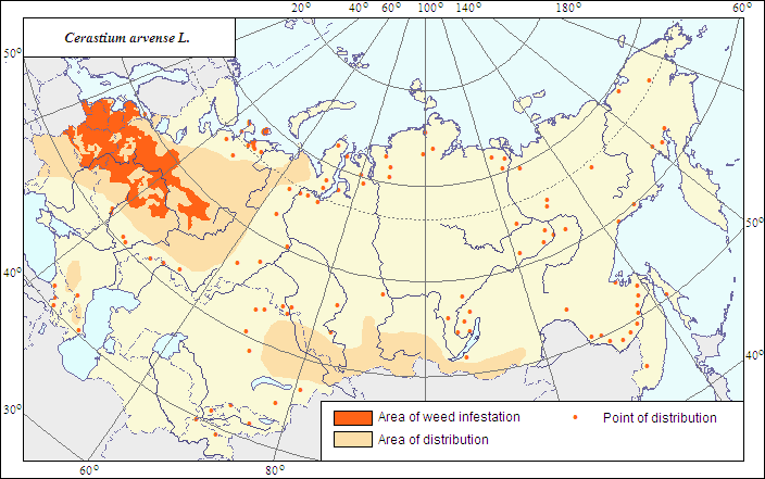
Area of distribution and weediness of Cerastium arvense L.
 Object description Download GIS-layers
Authors:
Object specialist - I.N.Nadtochii,GIS-specialist - I.A.Budrevskaya.
Date of creation:
20.05.2007.Scale:
1:20 000 000.Accuracy of the map:
It is created on materials of maps of natural scale 1: 80 000 000 and larger and on literature data.Projection:
"Alber's Equal Area Conic for the USSR", 9, 1001, 7, 100, 0, 44, 68, 0, 0.Basic content:
Vector map. Area of distribution is shown by polygon (main distribution) and by dots (sporadic distribution). Zone of weediness is shown by polygon.Accuracy of the classifier:
Area of main and sporadic distribution is shown. Within the weed area, the zones of its weediness are shown, established by criteria of occurrence (% of fields where this species is found) and abundance (expressed as projective cover of this species in the field (in % to the field area)) (Tanskii et al., 1998), i.e.; where the occurrence of this species exceeded 50% with its abundance (projective cover) more than 15%.Method of map production:
The area and zones of weediness are established according to the analysis of the open published maps and literature. A map compiled by Hulten E. & Fries M. (1986) is taken as a prototype. Distribution of C. jacea in the northeastern part of the USSR is corrected after the literature data. The area is expanded there after the map (Tolmachev, 1976) demonstrating mass records of the weed. Places of sporadic distribution are supplemented after literature data (Malyshev & Peshkova, 1993; Grigor.evskaya, 2000; Burdukovskaya & Pyzhikova, 2004) and maps (Glazkova, 2001). Zone of weediness is outlined after literature data with use of a computer map of arable lands. Criterion of its allocation is the indication of the weed in the literature as being a widespread weed species in Ukraine (Mel.nichuk & Kovalivs.ka, 1972), having abundance 2-3 points in perennial grasses in the Non-Czernozem Region (Korovin, 1982).Reference citations:
Burdukovskaya G.V. & Pyzhikova E.M., eds. 2004. Bulletin of laboratory of biodiversity of flora of the Baikal Siberia, no. 2. Ulan-Ude: BGU, 112 p. (in Russian).Glazkova E.A. 2001. Vascular flora of the islands of the eastern Gulf of Finland: structure and analysis. St.-Petersburg: St.-Petersburg University, 348 p. (in Russian).
Grigor.evskaya A.Ya. 2000. Flora of Voronezh town. Voronezh: Voronezh Univ., 198 p. (in Russian).
Hulten E. & Fries M. 1986. Atlas of North European Vascular Plants, North of the Tropic of Cancer: Konigstein. V. 1-3. 1172 p.
Korovina O.N., ed. 1982. Weed plants of the Non-Chernozem Zone of Russia. In: Catalogue of VIR world collection. N 338. Leningrad: VIR, 117 p. (in Russian).
Malyshev L.I. & Peshkova G.A., eds. 1993. Flora of Siberia. V. 6. Novosibirsk: Nauka. 308 p. (in Russian).
Melnichuk O.S. & Kovalivska G.M. 1972. Atlas of the most widespread weeds of the Ukraine. Kiev: Urozhai, 204 p. (in Ukrainian).
Shishkin, B.K., ed. 1963. Botanical atlas. Moscow-Leningrad: Izd-vo sel'skokhozyaistvennoi literatury, zhurnalov i plakatov, 504 p. (in Russian).
Tanskii V.I., Levitin M.M., Ishkova T.I. & Kondratenko V.I. 1998. Phytosanitary diagnostics in integrated management of cereals. In: Novozhilov K.V., ed. Compendium of methodical recommendations in plant protection. St. Petersburg: VIZR, p. 5-55. (in Russian).
Tolmachev A.I., ed. 1976. Flora of Northeast of the European part of the USSR. V. 2. Leningrad: Nauka, 316 p. (in Russian).