
Weeds
Area of distribution and harmfulness of Chenopodium polyspermum L.
 Object description Download GIS-layers
Authors:
Object specialist S.Yu.Larina,GIS-specialist I.A.Budrevskaya.
Data of creation:
22.12.2003.Scale:
1:20 000 000.Accuracy of map:
Created using maps of natural scale 1:5 000 000 - 1:80 000 000.Projection:
"Alber's Equal Area Conic for the USSR", 9, 1001, 7, 100, 0, 44, 68, 0, 0.Basic contents:
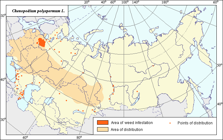
Vector map. Area of distribution is shown by polygons (basic distribution) and by points (sporadic distribution). Zones of harmfulness are shown by polygons.Accuracy of the classifier:
The weed area is subdivided into two zones, one representing species distribution, and the second where weed is considered a serious pest. Points represent locations where sporadic occurrence has been reported.The areas of distribution and harmfulness of Chenopodium polyspermum were established according to an analysis of open-published maps and literature. The areas of distribution were determined from the following source: (Hulten & Fries, 1986). Sites of sporadic distribution in the territory of Western Siberia were determined according to: (Hulten & Fries, 1986), (Krasnoborov, 1992) and were included in the area of basic distribution. Distribution was also expanded to the territories of the Baltic States and the adjacent regions of North-Western Russia according to: (Nikitin, 1983). Areas of harmfulness are established according to: (Korovina, 1982), (Rodionova, 2001) and adjusted using the boundaries of the Map of Arable Lands. In addition to the data of Hulten & Fries (1986), the sites of sporadic distribution of Chenopodium polyspermum are depicted in the Caucasus according to: (Grossgeim, 1945); and in Siberia according to: (Krasnoborov, 1992) and (Pronkina & Shcherbina, 1994).
Method of map production:
Published literature was reviewed, including Atlases, monographs and papers. Occurrence data were obtained from herbarium specimens, floras, monographs and papers. Data were then compiled through scanning and geo-referencing to develop a composite vector map. The biologist together with the GIS specialist, drew a composite weed distribution area based on compiled data Reference Citations:Grossgeim, A.A. 1945. Flora of Caucasus. Baku: Ac.Sc.Azerb.SSR. V.3: 321.
Hulten, E., Fries M. 1986. Atlas of North European Vascular Plants, North of the Tropic of cancer. Konigstein. V.1-3: 1172.
Keller, B.A., ed. 1934. Weed plants of the USSR. Leningrad: Ac.Sc.USSR. V.2: 244.
Komarov, V.L., Shishkin, B.K., ed. 1936. Flora of the USSR. Moscow-Leningrad: Ac.Sc.USSR. V.6: 956.
Koroljeva, I.E., Vilchevskaya, E.V., Ruhovich, D.I. 2003. Digital Arable Land Map. Laboratory of Soil Information of the Dokuchaev Soil Institute, Moscow.
Korovina O.N., ed. 1982. Weed plants of Non-Chernozem zone of Russia. In: Catalogue of VIR world collection. Issue 338. Leningrad: VIR. 117 pp. (In Russian)
Korsmo, E. 1933. Weed plants of modern farming. Moscow-Leningrad: State Publishing House of Kolchoz & Sovchoz Literature. 416 pp.
Krasnoborov, I.M., Malyshev, L.I., ed. 1992. Flora of Siberia. Novosibirsk: Nauka. V.5: 312.
Maevsky, P.F. 1954. Flora of the middle zone of the European part of the USSR. Moscow-Leningrad: State Publishing House of Agricul. Literat. 912 pp.
Nikitin, V.V. 1983. Weeds in the flora of the USSR. Leningrad: Nauka. 454 pp.
Pronkina, T.A., Shcherbina, S.S. 1994. To the flora of Middle Siberia. Bulletin MOIP. Sect biol 99(1): 104-112.
Rodionova, A.E. 2001. Segetal plants of upper Volga region. Saint Petersburg: VIZR. 99 pp. (In Russian)
Ulyanova, T.N. 1998. Weeds in the flora of Russia and other FSU states. Saint Petersburg: VIR. 343 pp.
Right and copyright:
All rights reserved.Copyright 2003 © S.Yu.Larina & I.A.Budrevskaya.