
Weeds
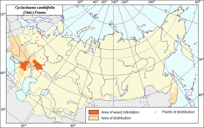
Area of distribution and weediness of Cyclachaena xanthiifolia (Nutt.) Fresen.
 Object description Download GIS-layers
Authors:
Specialist-biologist I.N. Nadtochii, GIS-specialist I.A. Budrevskaya.Date of creation:
20.2.2004.Scale:
1:20 000 000.Accuracy of map:
Map was created based on information taken from the published literature and maps of scale 1:10 000 000.Projection:
"Alber's Equal Area Conic for the USSR", 9, 1001, 7, 100, 0, 44, 68, 0, 0.Basic contents:
Vector map. Area of species distribution is shown by polygons, and sporadic distribution by points. Zones of weediness are shown by polygons.Accuracy of classifier:
The area defined includes the zone representing species distribution, and a second zone where the weed is considered a serious pest. Points represent locations where sporadic occurrence has been reported. The zone of weediness is determined according to literature, where the weed is reported as widespread, lowering yield of crops by 40-80% (Dyatlenko et al., 1987) and having a projective covering on a field of 28-30% (Bagmet et al., 2003). The area is coordinated with the Map of Arable Lands (Koroljeva et al., 2003).Method of map production:
Published literature was reviewed, including Atlases, monographs and papers. Occurrence data were obtained from herbarium specimens, floras, monographs and papers. The map of Komarov (1934) was used for base distribution. The following sources were used to make regional adjustments: in the European area (Veselovs.kii et al., 1988; Geidmann & Nikolaeva, 1954; Grigor'evskaya, 2000; Grossgeim, 1949; Dyatlenko, 1987; Prokudin, 1987; Ul.yanova, 1998; Yangurkina 1976); in the Far East (Ul.yanova, 1998; Korovina, 1983; Kharkevich, 1992); and the Caucasus (Galushko, 1980). The final area of distribution does not overstep the bounds of the area based on references and/or the border of Arable Lands Map (Koroljeva et al., 2003). Points of sporadic distribution were determined according to herbarium data (N.I. Vavilov Institute, V.L. Komarov Institute) and the following sources: Komarov (1959), Tsvelev (1994), Galushko (1980), Kharkevich (1992). Data were then compiled through scanning and geo-referencing to develop a composite vector map. The biologist, together with the GIS specialist, drew a composite weed distribution area based on compiled data.Reference citations:
Bagmet L.V., Sokolova T.D. 2003. Weediness of agricultural crops in a droughty zone of the Middle Volga Basin region. St. Petersburg-Pushkin. Vestnik zashchity rastenii 3: 67-70. (In Russian)Galushko, A.I. 1980. Flora of the Northern Caucasus. Rostov-na-Donu: Rostov University. V. 2: 352. (In Russian)
Geideman T.S., Nikolaeva L.P. 1954. On Distribution of some quarantine weeds in Moldavian SSR. In: News of Moldavian branch of AS of the USSR. Kishinev: State publishing House of Moldova. V. 1(15): 59-64. (In Russian)
Grigor.evskaya, A.Ya. 2000. Flora of Voronezh. Voronezh: Voronezh University. 198 p. (In Russian)
Grin.ko N.I., Titov A.Kh., Kvartin V.N., Semernikova A.I., Lapchenkov G.Ya., Dyatlenko, V.A. 1987. Weed plants and their control in the Rostov Region. Manual. Persianovka: Donskoi SKHI. 102 p. (In Russian)
Grossgeim, A.A. 1949. Keys to plants of the Caucasus. Moscow: Sovetskaya nauka. 747 pp. (In Russian)
Kharkevich S.S., ed. 1992. Vascular plants of the Soviet Far East. St. Petersburg: Nauka. V. 6: 250. (In Russian)
Komarov, V.L., ed. 1959. Flora of the USSR. Moscow & Leningrad: AN SSSR. V. 25: 557-558. (In Russian)
Koroljeva IE, Vilchevskaya EV, Ruhovich DI. 2003. Digital Arable Land Map. Laboratory of Soil Information of the Dokuchaev Soil Institute, Moscow, Russia [Based on: Yanvareva LF. (ed.), Martynjuk KN., Kisileva NM. 1989. Map of Land Use, Faculty of Geography, Moscow State University, Moscow, Russia.].
Korovina O.N., ed. 1983. Weed plants of the Soviet Far East (the list and distribution). In: Catalogue of VIR World Collection 374. Leningrad: VIR. 46 p. (In Russian)
Melnichuk O.S., Kovalivska G.M. 1972. Atlas of the most widespread weeds of the Ukraine. Kiev: Urozhai. 27-28 p. (In Ukrainian)
N.I. Vavilov All-Russian Institute of Plant Industry [WIR], St. Petersburg, Russia.
Prokudin Yu.N., ed. 1987. Keys to vascular plants of Ukraine. Kiev: Naukova dumka. 547 p. (In Russian)
Tsvelev, N.N., ed. 1994. Flora of the European part of the USSR. St. Petersburg: Nauka. 45 p. (In Russian)
Ul'yanova T.N. 1998. Weed plants in the flora of Russia and other FSU countries. St. Petersburg: VIR. 233 p. (In Russian)
V.L. Komarov Botanical Institute [LE], St. Petersburg, Russia.
Veselovs.kii I.V., Lisenko A.K., Man.ko Yu.P. 1988. Atlas-synopsis of weeds. Kyiv: Urozhai. 59 p. (In Ukrainian)
Yangurkina A.A. 1976. Floristic structure and distribution of weed plants in Kuibyshev Region. Leningrad-Pushkin: LSKHI. 24 p. (In Russian)