
Weeds
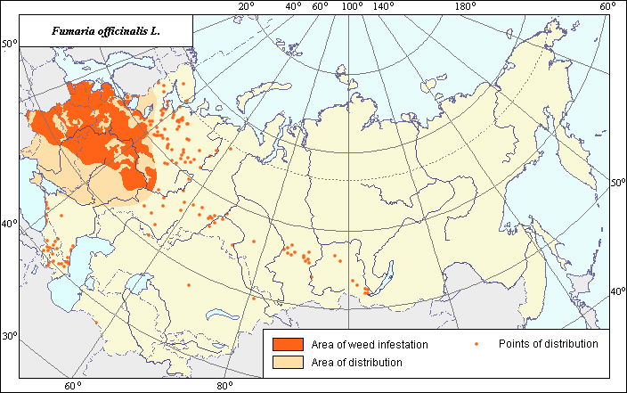
Area of distribution and harmfulness of Fumaria officinalis L.
 Object description Download GIS-layers
Authors:
Object specialist- T.D. Sokolova,GIS-specialist- I.A. Budrevskaja
Date of creation:
03.03.2004Scale:
1:20 000 000Accuracy of map:
Map was created based on materials of maps of natural scale 1:5 000 000 - 1:80 000 000 and on literature data.Projection:
"Alber's Equal Area Conic" USSR, 9, 1001, 7, 100, 0, 44, 68, 0, 0Basic contents:
Vector map. Area of species distribution is shown by polygons, and sporadic distribution by points. Zones of weediness are shown by polygons.Accuracy of classifier:
The weed area is subdivided into two zones, one representing species distribution, and the second where weed is considered a serious pest. Points represent locations where sporadic occurrence has been reported.Method of map production:
Published literature was reviewed, including Atlases, monographs and papers. Occurrence data were obtained from herbarium specimens, floras, monographs and papers. The map of Hulten & Fries (1986) was used to determine the area of distribution. The limits of the zone of harmfulness were determined according to Nikitin (1983) and adjusted according to the sources below, as well as to the limits of the Arable Land Map (Koroljeva et al., 2003). Data were then compiled through scanning and geo-referencing to develop a composite vector map. The biologist, together with the GIS specialist, drew a composite weed distribution area based on compiled data.Reference citations:
Grossgeim, A.A. 1950. Flora of the Caucasus. Moscow-Leningrad: AN SSSR. V. 4: 106. (In Russian)Hulten E., Fries M. 1986. Atlas of North European Vascular Plants, North of the Tropic of Cancer. Konigstein. V. 1-3: 1172.
Koroljeva IE, Vilchevskaya EV, Ruhovich DI. 2003. Digital Arable Land Map. Laboratory of Soil Information of the Dokuchaev Soil Institute, Moscow, Russia [Based on: Yanvareva LF. (ed.), Martynjuk KN., Kisileva NM. 1989. Map of Land Use, Faculty of Geography, Moscow State University, Moscow, Russia.].
Malyshev, L.I. & G.A. Peshkova, eds. 1994. Flora of Siberia. Novosibirsk: Nauka. V. 7: 43. (In Russian)
Melnichuk O.S., Kovalivska G.M. 1972. Atlas of the most widespread weeds of the Ukraine. Kiev: Urozhay. 204 pp. (In Ukrainian)
Nikitin V.V. 1983. Weed plants of the USSR flora. Leningrad: Nauka. 195 p. (In Russian)
Polozhiy A.V., Loshkaryeva L.N., Gudoshnikov S.V. 1975. Flora of the Krasnoyarsk Territory. Issue V (part 4). Tomsk: Tomsk University. 8-9 pp. (In Russian)
Shlyakova E.V. 1971. On weed infestation of crops of Mesen district of the Arkhangelsk Region. Botanicheskii zhurnal, 56(6): 863-868. (In Russian)
Tolmachev, A.I., ed. 1976. Flora of North-East of the European part of the USSR. Leningrad: Nauka. V. 3: 45. (In Russian)
Ulyanova T.N. 1983. Weed plants of the Soviet Far East. In: Korovina O.N., editor. The catalogue of world collection of VIR. Issue 374. Leningrad: VIR. 21 p. (In Russian)