
Weeds
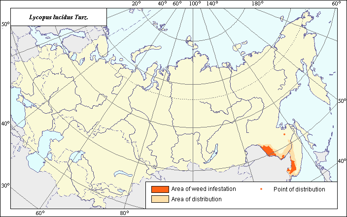
Area of distribution and weediness of Lycopus lucidus Turz.
 Object description Download GIS-layers
Authors:
Object specialist N.N. Luneva,GIS-specialist I.A. Budrevskaya.
Date of creation:
24.06.2005Scale:
1:20 000 000.Accuracy of map:
Map was created based on information taken from open-published literature and on maps of natural scale 1: 5 000 000 - 1: 100 000 000.Projection:
"Alber's Equal Area Conic for the USSR", 9, 1001, 7, 100, 0, 44, 68, 0, 0.Basic contents:
Vector map. Area of species distribution is shown by polygons and sporadic distribution by points. Zones of weediness are shown by polygons.Accuracy of classifier:
The weed area is subdivided into two zones, one representing species distribution, and the second where weed is considered a serious pest. Points represent locations where sporadic occurrence has been reported. The zone of weediness was allocated according to criteria of occurrence and abundance (Tanskii et al., 1998), i.e., where the field abundance (projective cover) is more than 15%.Method of map production:
Published literature was reviewed, including Atlases, monographs and papers. Occurrence data were obtained from herbarium specimens, floras, monographs and papers. The following sources were used to determined the map area: Keller (1935), Nikitin (1983), Korchagina et al. (1972), Ul.yanova (1998). The zone of main distribution is located in the Russian Far East, corrected according to the map of distribution of mixed and deciduous forests in the Far East, and also in adjacent areas of the south of Eastern Siberia according to the following sources: Keller (1935), Nikitin (1983). The zone of weediness is located within the area of arable lands (Korchagina et al., 1972). Sporadic distribution areas were determined according to the following herbaria: Moscow State University, Barnaul State University and the V.L. Komarov Botanical Institute (RAN).Data were compiled through scanning and geo-referencing to develop a composite vector map. The biologist, together with the GIS specialist, drew a composite weed distribution area based on compiled data.
Reference citations:
Keller B.A., ed. 1935. Weed plants of the USSR. V. 4. Moscow-Leningrad: AN SSSR. 416 p. (In Russian)Korchagina V.A., Penchukov V.M. Morozov N.A., Smashevskaya G.A., Kolomiitsev F.B., Trubeeva A.I., Baranova M.M. 1972. Control of weeds in the Far East. Khabarovsk: Khabarovsk Publishing House. 160 p. (In Russian)
Lomonosov Moscow State University [MW], Moscow, Russia.
Nikitin V.V. 1983. Weeds in the flora of the USSR. Leningrad: Nauka. 454 p. (In Russian)
Ulyanova T.N. 1998. Weeds in the flora of Russia and other CIS states. St. Petersburg: VIR. 344 p. (In Russian)
University of Barnaul, Altai State University [ALTB], Barnaul, Russia.
V.L. Komarov Botanical Institute RAN [LE], St. Petersburg, Russia.