
Weeds
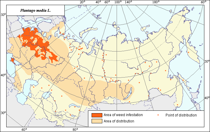
Area of distribution and weediness of Plantago media L.
 Object description Download GIS-layers
Authors:
Object specialist I.N. Nadtochii,GIS-specialist I.A. Budrevskaya.
Date of creation:
5.04.2005Scale:
1:20 000 000.Accuracy of map:
Map was created based on information taken from open-published literature and on maps of natural scale 1:80 000 000 - 1:5 000 000.Projection:
"Alber's Equal Area Conic for the USSR", 9, 1001, 7, 100, 0, 44, 68, 0, 0Basic contents:
Vector map. Area of species distribution is shown by polygons and sporadic distribution by points. Zones of weediness are shown by polygons.Accuracy of classifier:
The weed area is subdivided into two zones, one representing species distribution, and the second where weed is considered a serious pest. Points represent locations where sporadic occurrence has been reported. The zone of weediness was allocated according to criteria of occurrence (% of fields where this species is found) and abundance (expressed as projective cover of this species in the field) (Tanskii et al., 1998), i.e., where the occurrence of this species exceeded 50% with its abundance (projective cover) being more than 15%.Method of map production:
Published literature was reviewed, including Atlases, monographs and papers. Occurrence data were obtained from herbarium specimens, floras, monographs and papers. The map from Hulten & Fries (1986) was used as a prototype and was adjusted according to the following sources: the area border on Kola Peninsula was shifted slightly eastward according to Poyarkova (1966); in Arkhangel.sk Region it is shifted slightly northward according to Hulten & Fries (1986) and Tolmachev A.I. (1977); the Crimea was included into the area according to the data on the species weediness by Vasil.ev (1929). Sporadic distribution was determined according to Hulten & Fries (1986), Poyarkova (1966), Tolmachev (1977), Dorogostaiskaya (1972), Malyshev & Peshkova (1976), and the herbarium of Moscow State University. The zone of weediness was outlined according to literature data and the map of arable lands (Koroljeva et al., 2003). Criterion used was the indication that the weed has an abundance to 3 points in perennial grasses in Non-Chernozem Zone (Shlyakova, 1982), as a weed plant in Brest and Gomel Regions in grain crops (Kozlovskaya & Simonovich, 1966), and having an occurrence of 78% in orchards of Crimea (Vasil.ev, 1929). Data were then compiled through scanning and geo-referencing to develop a composite vector map. The biologist, together with the GIS specialist, drew a composite weed distribution area based on compiled data.Reference citations:
Dorogostaiskaya E.V. 1972. Weed plants of the Far North of the USSR. Leningrad: Nauka. 172 p. (In Russian)Hulten E., Fries M. 1986. Atlas of North European Vascular Plants, North of the Tropic of Cancer. Konigstein. V. 1-3. 1172 p.
Koroljeva IE, Vilchevskaya EV, Ruhovich DI. 2003. Digital Arable Land Map. Laboratory of Soil Information of the Dokuchaev Soil Institute, Moscow, Russia [Based on: Yanvareva LF. (ed.), Martynjuk KN., Kisileva NM. 1989. Map of Land Use, Faculty of Geography, Moscow State University, Moscow, Russia.].
Kozlovskaya N.V., Simonovich L.G. 1966. Features of weed distribution on turfy-podzol soils of Polesye region. In: Yurkevich I.D., ed. Geobotanical research. Minsk: Nauka i tekhnika. 56-64 p. (In Russian)
Malyshev, L.I. & G.A. Peshkova, eds. 1979. Flora of Central Siberia. Novosibirsk: Nauka. V. 2. 1048 p. (In Russian)
Moscow State University [MWG], Moscow, Russia.
Poyarkova, A.I., ed. 1966. Flora of the Murmansk Region. V. 5. Moscow-Leningrad: AN SSSR. 551 p. (In Russian)
Shlyakova E.V. 1982. Keys to field weed plants of Non-Chernozem zone. Leningrad: Kolos. 208 p. (In Russian)
Tanskii V.I., Levitin M.M., Ishkova T.I., Kondratenko V.I. 1998. Phytosanitary diagnostics in integrated management of cereals. In: Novozhilov K.V., ed. Compendium of methodical recommendations in plant protection. St. Petersburg: VIZR. 5-55 p. (In Russian)
Tolmachev, A.I. ed. 1977. Flora of North-East of the European part of the USSR. V. 4. Leningrad: Nauka. 312 p. (In Russian)
Vasil.ev V. 1929. Weed plants of orchards in Crimea and their control. Visnik sadivnitstva, vinogradnitstva ta gorodnitstva (Kharkiv: Narkomzemsprav USSR) 3-4: 166-171. (In Russian)