
Weeds
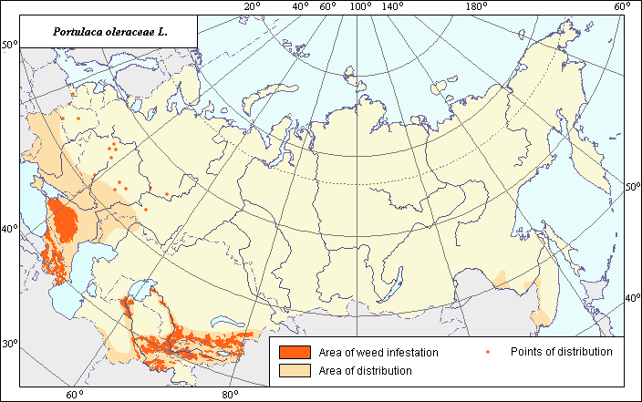
Species distribution and zones of weediness of Portulaca oleracea L.
 Object description Download GIS-layers
Authors:
Object specialist I.N. Nadtochij, GIS-specialist M.I. Saulich.Data of creation:
16.01.2004.Scale:
1:20 000 000.Accuracy of the map:
Created using maps of natural scale 1:10 000 000-1:80 000 000 and on data from the literature.Projection:
"Alber's Equal Area Conic" USSR, 9, 1001, 7, 100, 0, 44, 68, 0, 0.Basic contents:
Vector map. Area is shown by polygons (basic distribution) and by points (sporadic distribution). Zone of weediness is shown by polygons.Accuracy of the classifier:
Areas of distribution and weediness zones of Portulaca oleracea were established according to an analysis of open-published maps and literature. Distribution of Portulaca oleraceae was determined according to: Volkov, (1983) and Hulten & Fries, (1986). The northwest part of the area of distribution (area of Ukraine) was determined according to: Hulten & Fries, (1986) and Volkov, (1983). In Central Asia the Volkov mountain areas were removed from maps and the Central Asia territory was extended to the north and to the east according to the map of the Arable Lands (Koroljeva et al., 2003). The area of distribution in the Far East is based on Voroshilov (1966) and the Map of Arable lands . Point data represent sporadic distribution based on herbarium material obtained from VIR and the V.L. Komorov Institute of Botany. The following references were also used: Grigorevskaja, (2000); Maevskij, (1954); Popchenkov, (1993); and Dorogkin, (1949). The zone of weediness was determined according to the following sources: Burygin et al., (1975); Sabirov, (1975); Gajdashkin, (1936); Galimova, (1975); Dokuchaev, (1973); Ilina, (1935); Catalogue of the VIR World collection, (1989); Arkhangelsk, (1953) and Suhin et al., (1983).Method of map production:
Published literature was reviewed, including Atlases, monographs and papers. Occurrence data were obtained from herbarium specimens, floras, monographs and papers. Data were then compiled through scanning and geo-referencing to develop a composite vector map. The biologist, together with the GIS specialist, drew a composite weed distribution area based on compiled data.Reference citations:
Arkhangel.skii M.P. 1953. Weed plants and their control. Krasnodar. 30 pp.Burygin V.A., Dzhangurazov F.H. 1975. Weed vegetation of the irrigated lands of Uzbekistan and biological bases of it control. Weed vegetation of the irrigated lands of Central Asia. Nauchnye trudy Tashkentskogo sel'skokhozyaistvennogo instituta. Tashkent. 1-7 pp.
Dokuchaev V.M., ed. 1973. Green Enemies: Weeds of the Stavropol Territory and their control. Stavropol: Stavropol.skoe knizhnoe izdatel.stvo. 168 pp.
Dorogkin, N.A., ed. 1949. Flora of BSSR. Minsk. V. 2: 218 pp.
Gaidashakin V.I., Makashvilli A.K, Yabrova V.S., Yaroshenko P.D. 1936. Weed plants of wet subtropics of the USSR and their control. Sukhumi. N. 31: 136 pp.
Galimova F.G. 1975. Some data on weed vegetation of the irrigated lands of the state farm "Socialism" and the collective farm "Uzbekistan" of the Voroshilov district of the Syr-Darya region. Weeds of irrigated lands of Middle Asia. Scientific Papers of Tashkent Agricultural Institute. Tashkent. 61-66 pp.
Grigorevskaya, A.Ya. 2000. Flora of Voronezh city. Voronezh: Voronezh University. 134 pp.
Hulten E., Fries M. 1986. Atlas of North European Vascular Plants, North of the Tropic of cancer. In: 3 V. Konigstein. V. 1-3. 1172 pp.
Ilina A. 1935. Materials for studying weed vegetation of tobacco plantations Abhazii. In: The Collection of works of sector agricultural technicians and chemicalization. Krasnodar. Issue 120. V. 2: 139-157.
Koroljeva IE, Vilchevskaya EV, Ruhovich DI. 2003. Digital Arable Land Map. Laboratory of Soil Information of the Dokuchaev Soil Institute, Moscow, Russia [Based on: Yanvareva LF. (ed.), Martynjuk KN., Kisileva NM. 1989. Map of Land Use, Faculty of Geography, Moscow State University, Moscow, Russia.].
Popchenkov V.G. 1993. On new and infrequent species of flora Tatarstana. Botanicheskii zhurnal 78(9): 73-79.
Sabirov B.Z. 1975. Weeds of sprinkling and collection-drainage system in S.M. Kirov educational farm of the Tashkent agricultural institute and their control. Weeds of irrigated lands of Middle Asia. Scientific Papers of Tashkent Agricultural Institute. Tashkent. N 43: 67-72.
Ulyanova T.N. 1989. Field weed plants of cotton in the USSR. In: Agaev M.G., ed. Catalogue of VIR world collection. Leningrad: VIR. N. 499: 15, 40. (In Russian)
Volkov A.N., ed. 1935. Areas of distribution of the major weed plants in the USSR. Moscow-Leningrad: Izd-vo kolkhoznoi i sovkhoznoi literatury. 152 pp.
Voroshilov, V.N. 1966. Flora of the Soviet Far East. Moscow. 117 pp.
Zhdanguzov F.Kh., Loi N.P. 1975. Weed plants on sowings of cotton plants in Surkhan-Darya Region. In: Weeds of Irrigated lands of Middle Asia. Scientific Papers of Tashkent Agricultural Institute. Tashkent. N. 43: 16-24.