
Weeds
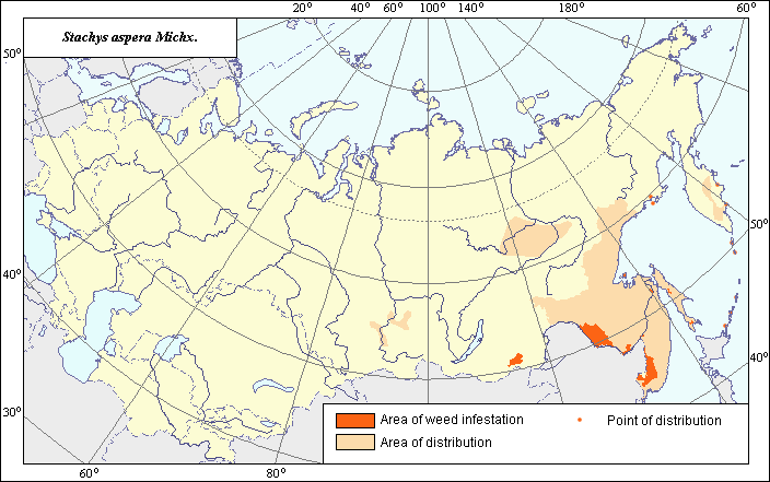
Area of distribution and weediness of Stachys aspera Michx.
 Object description Download GIS-layers
Authors:
Object specialist T.D. SokolovaGIS-specialist I.A. Budrevskaya
Date of creation:
06.12.2004.Scale:
1:20,000,000.Accuracy of map:
Map was created using maps of natural scale 1:5,000,000 and published data.Projection:
"Alber's Equal Area Conic" USSR, 9, 1001, 7, 100, 0, 44, 68, 0, 0.Basic contents:
Vector map. Main distribution area is shown by polygons, while sporadic distribution is shown by points. Zone of weediness is shown by a polygon.Accuracy of classifier:
Within the weed distribution area, zones of main and sporadic distribution and a zone of weediness are shown, where S. aspera is a pernicious weed. The zone of weediness was established according to criteria of species occurrence and abundance (Tanskii et al., 1998). Within this zone, S. aspera is characterized by 75-100% frequency of occurrence and 4-5 points of abundance.Mapping procedure:
Areas of main distribution, sporadic distribution and weediness were established following an analysis of published maps and literature. The distribution area of S. aspera was drawn in accordance with the map by Kharkevich (1995) and data from Krasnoborov & Kashina (1979), Ulyanova (1981; 1983), Tolmachev (1966; 1974a; 1974b), Malyshev (1997), Buch et al. (1981), and Nikitin (1983). The boundaries of the zone of weediness were established using Nikitin (1983) and Ulyanova (1981; 1983; 1998) and further specified in accordance with data on abundance and frequency of species occurrence taken from the below-mentioned references and adjusted in accordance with the boundaries of arable lands. According to Nikitin, S. aspera is a comparatively resistant weed in crops and sometimes occurs abundantly in fallow lands and abandoned rice fields in Eastern Siberia and in the Far East. According to Ulyanova's data, S. aspera is a widespread weed of soy and other tilled crops, as well as of grain crops in the Far East (especially in the Amur Region).Sources of data:
Buch, T.G., Kachura, N.N., Shvydkaya, V.D., & Andreeva, E.R. 1981. Weed plants of the Primoskii Territory and their control. Vladivostok: Dal'nevostochnoe Publishing House, 243 p. (in Russian).Kharkevich, S.S., ed. 1995. Vascular plants of the Soviet Far East. V.7. St. Petersburg: Nauka, 395 p. (in Russian).
Krasnoborov I.M., ed. 1979. Keys to plants of the South of the Krasnoyarsk Territory. Novosibirsk: Nauka, 672 p. (in Russian).
Malyshev, L.I., ed. 1997. Flora of Siberia. V.11. Novosibirsk: Nauka, 296 p. (in Russian).
Nikitin, V.V. 1983. Weed plants in the flora of the USSR. Leningrad: Nauka, 454 p. (in Russian).
Tanskii, V.I., Levitin, M.M., Ishkova, T.I. & Kondratenko, V.I. 1998. Phytosanitary diagnostics in integrated managemant of cereals. In: Novozhilov, K.V., ed. Compendium of methodical recommendations in plant protection. St. Petersburg: VIZR, p.5-55. (in Russian).
Tolmachev A.I., ed. 1966. Keys to plants of the Primorskii Territory and the Amur River Territory. Moscow-Leningrad: Nauka, 490 p. (in Russian).
Tolmachev A.I., ed. 1974a. Keys to higher plants of Sakhalin and Kuril Islands. Leningrad: Nauka, 372 p. (in Russian).
Tolmachev A.I., ed. 1974b. Keys to higher plants of Yakutia. Novosibirsk: Nauka, 544 p. (in Russian).
Ulyanova, T.N. 1981. Weed plants in wheat of the USSR. In: Korovina, O.N., ed. Catalogue of VIR world collection. Issue 320. Leningrad: VIR, 68 p. (in Russian).
Ulyanova, T.N. 1983. Weed plants of the Soviet Far East. In: Korovina, O.N., ed. Catalogue of VIR world collection. Issue 374. Leningrad: VIR, 48 p. (in Russian).
Ulyanova, T.N. 1998. Weed plants in the flora of Russia and other CIS states. St. Petersburg: VIR, 344 p. (in Russian).
Right and copyright:
All rights reserved.Copyright 2004 © T.D. Sokolova, I.A. Budrevskaya (vector map, description).
T.D. Sokolova is the author of the pictures (VIZR).