
Weeds
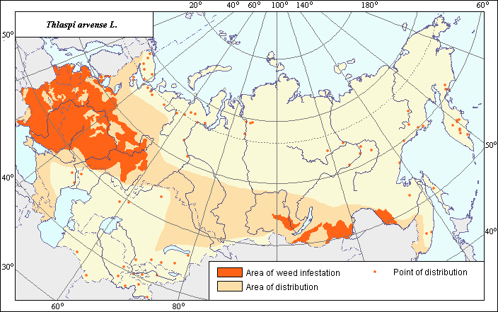
Area of distribution and harmfulness of Thlaspi arvense L.
 Object description Download GIS-layers
Authors:
Object specialist - S.Yu. Larina, GIS-specialist - I.A. Budrevskaya.Data of creation:
03.03.2004.Scale:
1:20 000 000.Accuracy of map:
Map was created based on materials of maps of natural scale 1:5 000 000 - 1:80 000 000.Projection:
"Alber's Equal Area Conic for the USSR", 9, 1001, 7, 100, 0, 44, 68, 0, 0.Basic contents:
Vector map. Area of species distribution is shown by polygons, and sporadic distribution by points. Zones of weediness are shown by polygons.Accuracy of classifier:
The weed area is subdivided into two zones, one representing species distribution, and the second where the weed is considered a serious pest. Points represent locations where sporadic occurrence have been reported. The zone of harmfulness were established according to criteria of occurrence (% of fields where this species is found) and abundance (expressed as the projective cover of this species by % of field area) and was determined to be where the occurrence of this species exceeded 20% and abundance was more than 15% (Tanskii et al., 1998).Method of map production:
Published literature was reviewed, including Atlases, monographs and papers. Occurrence data were obtained from herbarium specimens, floras, monographs and papers. Data were then compiled through scanning and geo-referencing to develop a composite vector map. The biologist, together with the GIS specialist, drew a composite weed distribution area based on compiled data. The area of distribution was determined according to the maps of Hulten & Fries (1986) and adjusted at the borders according to the following sources: The area is extended to Eastern Siberia (Malyshev & Peshkova, 1994) and to the Far East (Korovina, 1983). The map of Volkov (1935) was also used as a reference. The areas of harmfulness were determined according to Nikitin (1983) and adjusted according to the limits of the Arable Land Map (Koroljeva et al., 2003). In addition to the data of Hulten & Fries (1986), the sites of sporadic distribution were determined according to the following sources: in the Far East by Kharkevich (1988); in the northern regions of the European part of Russia/Siberia by Dorogostaiskaya (1972), Tolmachev (1976) and Malyshev & Peshkova (1994). The sites of sporadic distribution in the Caucasas (Grossgeim, 1950) were included in the main distribution area.Reference citations:
Agaev M.G., ed. 1988. Main agricultural weeds in crops of the Leningrad Region. In: Catalogue of VIR world collection. Leningrad: VIR. N. 468: 112. (In Russian)Dorogostaiskaya E.V. 1972. Weed plants of the Far North of the USSR. Leningrad: Nauka. 172 pp. (In Russian)
Grossgeim A.A. 1945. Flora of the Caucasus. Moscow-Leningrad: AN SSSR. V. 4: 311. (In Russian)
Hulten E., Fries M. 1986. Atlas of North European Vascular Plants, North of the Tropic of cancer. Konigstein. V. 1-3: 1172.
Keller B.A., ed. 1934. Weed plants of the USSR. Leningrad: AN SSSR. V. 3: 448. (In Russian)
Kharkhevich S.S., ed. 1988. Vascular plants of the Soviet Far East. Leningrad: Nauka. V. 3: 421. (In Russian)
Komarov V.L, Bush N.A., eds. 1939. Flora of the USSR. Moscow-Leningrad: AN SSSR. V. 8: 696. (In Russian)
Koroljeva IE, Vilchevskaya EV, Ruhovich DI. 2003. Digital Arable Land Map. Laboratory of Soil Information of the Dokuchaev Soil Institute, Moscow, Russia [Based on: Yanvareva LF. (ed.), Martynjuk KN., Kisileva NM. 1989. Map of Land Use, Faculty of Geography, Moscow State University, Moscow, Russia.].
Korovina O.N., ed. 1983. Weed plants of the Soviet Far East (the list and distribution). In: Catalog of VIR World Collection. Leningrad: VIR. N. 374: 46. (In Russian)
Korsmo E. 1933. Weed plants of modern farming. Moscow-Leningrad: State Publishing House of Kolchoz & Sovchoz Literature. 416 pp. (In Russian)
Maltsev A.I. 1937. Atlas of the main weed species of the USSR. Moscow-Leningrad: Selkhozgiz. V. 1: 168. (In Russian)
Malyshev L.I., Peshkova G.A. 1994. Flora of Siberia. Novosibirsk: Nauka. V. 7: 312. (In Russian)
Nikitin V.V. 1983. Weed plants of the USSR flora. Leningrad: Nauka. 454 pp. (In Russian)
Tanskii V.I., Levitin M.M., Ishkova T.I., Kondratenko V.I. 1998. Phytosanitary diagnostics in integrated managemant of cereals. In: Novozhilov K.V., ed. Compendium of methodical recommendations in plant protection. Saint Petersburg: VIZR. 5-55 p. (In Russian)
Tolmachev A.I., ed. 1976. Flora of North-East of the European part of the USSR. Leningrad: Nauka. V. 3: 294. (In Russian)
Ulyanova T.N. 1998. Weed plants in flora of Russia and other CIS countries. St. Petersburg: VIR. 343 pp. (In Russian)
Volkov A.N., ed. 1935. Areas of distribution of the major weed plants in the USSR. Moscow-Leningrad: Publishing House of Kolkhoz & Sovkhoz Literature. 153 pp. (In Russian)
Zotova A.P. 1971. Weed plants and their control. Leningrad: Lenizdat. 144 pp. (In Russian)
Right and copyright:
Copyright on this map and description belongs to its authors.All rights reserved. Copyright 2003© S.Yu. Larina & I.A. Budrevskaya.
Picture was reproduced from publication by Maltsev A.I. (1937).