
Weeds
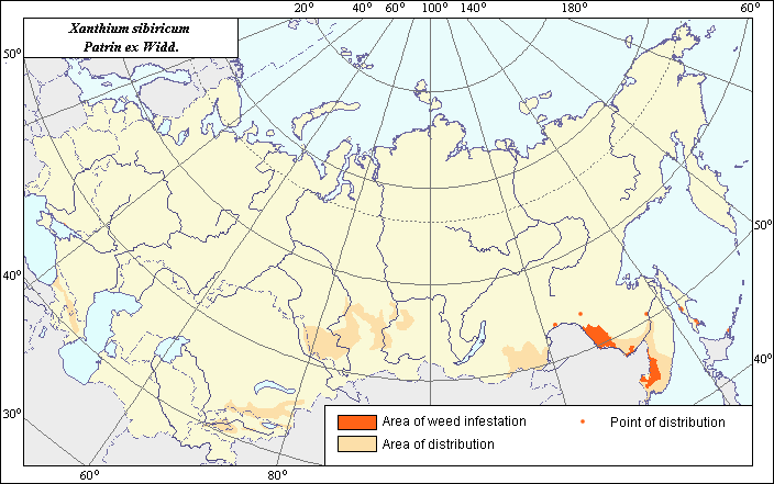
Area of distribution and weediness of Xanthium sibiricum Patrin ex Widd.
 Object description Download GIS-layers
Authors:
Object specialist I.N. Nadtochii,GIS-specialist I.A. Budrevskaya.
Date of creation:
20.04.2005Scale:
1:20 000 000.Accuracy of map:
Map was created based on information taken from open-published literature and on maps of natural scale 1:24 000 000 - 1:5 000 000.Projection:
"Alber's Equal Area Conic for the USSR", 9, 1001, 7, 100, 0, 44, 68, 0, 0Basic contents:
Vector map. Area of species distribution is shown by polygons and sporadic distribution by points. Zones of weediness are shown by polygons.Accuracy of classifier:
The weed area is subdivided into two zones, one representing species distribution, and the second where the weed is considered a serious pest. Points represent locations where sporadic occurrence has been reported. The zone of weediness was allocated according to criteria of occurrence (% of fields where this species is found) and abundance (Tanskii et al., 1998), i.e., where the occurrence of this species exceeded 50% with its field abundance (projective cover) being more than 15%.Method of map production:
Published literature was reviewed, including Atlases, monographs and papers. Occurrence data were obtained from herbarium specimens, floras, monographs and papers. The X. sibiricum area map was compiled on the basis of the weed distribution map (Kharkevich, 1992), reference data on the species distribution in floristic regions by Krasnoborov (1997) and Komarov (1959) and the following compiled maps of the weed distribution in administrative districts (blue line): Korovina (1983), Tolmachev (1966), Vvedenskii (1965). In the Far East the area was allocated according to the map of the weed compiled after literature data (blue line), Kharkevich (1992), Herbaria of the All-Russian Institute of Plant Industry and Botanical Institute RAN. In Siberia the area was allocated according to the map of Krasnoborov (1997) (blue line) and Malyshev & Peshkova (1979). In Middle Asia the area was outlined in Kirghizia only according to Nikitina (1979) and Vvedenskii (1965). In the Caucasus the area was determined according to the reference data on the species presence in southern and eastern Transcaucasia (Komarov, 1959). Sporadic distribution of X. sibiricum was determined according to the following sources: Kharkevich (1992), Dobrochaev et al. (1987), Vorob.ev (1974), the herbarium of the Botanical Institute RAN. The zone of weediness was allocated according to literature data and map of arable lands. Criterion of its allocation is the indication of the weed in the literature as a malignant weed, weed plant having 100% occurrence on soya and barley crops and 88% occurrence on wheat in the Far East according to the following sources: Korovina (1981), Korchagina et al. (1972), Ul.yanova (1979), Ul.yanova (1990). The map of arable lands was also used to determine adjustments to all areas (Koroljeva et al., 2003). Data were then compiled through scanning and geo-referencing to develop a composite vector map. The biologist, together with the GIS specialist, drew a composite weed distribution area based on compiled data.Reference citations:
Dobrochaev D.N., Kotov M.I., Prokudin Yu.N., eds. 1987. Keys to higher plants of Ukraine. Kiev: Naukova dumka. 547 p. (In Russian)V.L. Komarov Botanical Institute [LE], St. Petersburg, Russia.
N.I. Vavilov All-Russian Institute of Plant Industry [WIR], St. Petersburg, Russia.
Kharkevich S.S., ed. 1992. Vascular plants of the Soviet Far East. V. 6. Saint Petersburg: Nauka. 428 p. (In Russian)
Komarov, V.L., ed. 1959. Flora of the USSR. V. 25. Moscow-Leningrad: AN SSSR. 631 p. (In Russian)
Korchagina V.A., Penchukov V.M., Morozov N.A., Smashevskaya G.A., Kolomiitsev F.B., Trubeeva A.I., Baranova M.M. 1972. Control of weeds in the Far East. Khabarovsk: Khabarovsk Publishing House. 160 p. (In Russian)
Koroljeva IE, Vilchevskaya EV, Ruhovich DI. 2003. Digital Arable Land Map. Laboratory of Soil Information of the Dokuchaev Soil Institute, Moscow, Russia [Based on: Yanvareva LF. (ed.), Martynjuk KN., Kisileva NM. 1989. Map of Land Use, Faculty of Geography, Moscow State University, Moscow, Russia.].
Korovina O.N., ed. 1981. Weed plants of wheat sowings in the USSR. Catalogue of VIR world collection. N. 320. Leningrad: VIR. 68 p. (In Russian)
Korovina O.N., ed. 1983. Weed plants of the Soviet Far East (the list and distribution). Catalogue of VIR world collection. N. 374. Leningrad: VIR. 46 p. (In Russian)
Krasnoborov, I.M. 1997. Flora of Siberia. V. 13. Novosibirsk: Nauka. 342 p. (In Russian)
Malyshev, L.I. & G.A. Peshkova, eds. 1979. Flora of Central Siberia. V. 2. Novosibirsk: Nauka. 1048 p. (In Russian)
Nikitina E.V., ed. 1979. Keys to plants of agricultural zone of Kyrgyzstan. Frunze: Ilym. 490 p. (In Russian)
Tanskii V.I., Levitin M.M., Ishkova T.I., Kondratenko V.I. 1998. Phytosanitary diagnostics in integrated management of cereals. In: Novozhilov K.V., ed. Compendium of methodical recommendations in plant protection. St. Petersburg: VIZR. 5-55 p. (In Russian)
Tolmachev A.I., ed. 1966. Keys to plants of Primorskii Territory and Amur Region. Moscow-Leningrad: Nauka. 492 p. (In Russian)
Ul.yanovaб T.N. 1979. Weed-field flora of the Far East. Zashchita rastenii 11: 32-33. (In Russian)
Ulyanova T.N. 1990. Adventive plants in segetal flora of the USSR. In: Kondratenko V.I., ed. Abstracts of 1st herbology meeting in memory to N.A. Shipinov and V.A. Voevodin (10-12 April, 1990). Leningrad: VANTO. 33-36 p. (In Russian)
Vorob.ev D.P., Voroshilov V.N., eds. 1974. Keys to higher plants of Sakhalin and Kurils. Leningrad: Nauka. 372 p. (In Russian)
Vvedenskii, A.I., ed. 1965. Flora of Kirghiz SSR. V. 11. Frunze: Ylym. 611 p. (In Russian)