Relatives
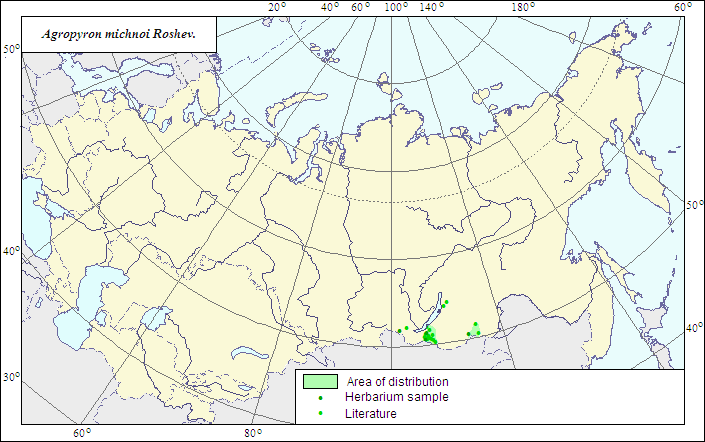
Range of distribution of Michno.s Wheatgrass (Agropyron michnoi) .
 Object description Download GIS-layers
|
|

RelativesRange of distribution of Michno.s Wheatgrass (Agropyron michnoi) . Object description Download GIS-layers
Author:The expert-botanist and the GIS expert - L.L.Malyshev.Date of creation:25.06.2007Scale:1:20 000 000.Accuracy of the map:The map is based on data of 1:12 000 000-1:40 000 000 scale maps.Projection:"Albers Equal-Area Conic Projection for USSR", 9, 1001, 7, 100, 0, 44, 68, 0, 0Basic contents:The map is a vector file consisting of 1 basic and 3 subject layers. The species range is represented by a polygon and dots.Accuracy of the qualifier:The dots represent information on the species localities according to herbarium materials of LE (1) and published sources (2), the polygon - generalized information on the species distribution.Method of the map contruction:The map of the species range is based on coordinates according to herbarium materials and the database included in the Information Retrieval System "Crop Wild Relatives in Russia" (STC Informregistr 0229905883, 1999), and on published maps (Malyshev, Peshkova, 1990). The species range is limited by sand massifs in the valleys of the Selenga and The Onon Rivers.References:Malyshev LI., Peshkova GA., ed. 1990. Flora of Siberia. V.4. Poaceae (Gramineae). Novosibirsk: Nauka. 361 p. (In Russian).Rights and copyrights:The copyrights of the map and descriptions are held by their author. |
|
|
|
|
Web design — |