
Relatives
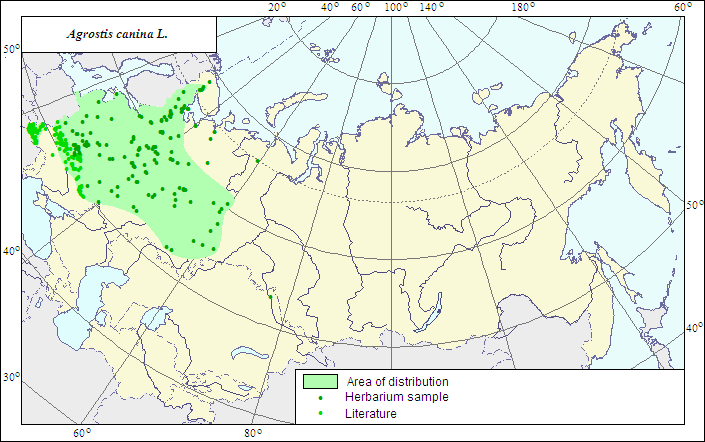
Range of distribution of Velvet Bent (Agrostis canina) .
 Object description Download GIS-layers
Author:
The expert-botanist and the GIS expert - L.L.Malyshev.Date of creation:
25.12.2007Scale:
1:20 000 000.Accuracy of the map:
The map is based on data of 1:12 000 000-1:40 000 000 scale maps.Projection:
"Albers Equal-Area Conic Projection for USSR", 9, 1001, 7, 100, 0, 44, 68, 0, 0Basic contents:
The map is a vector file consisting of 1 basic and 3 subject layers. The species range is represented by a polygon and dots.Accuracy of the qualifier:
The dots represent information on the species localities according to herbarium materials of LE (1) and published sources (2), the polygon - generalized information on the species distribution.Method of the map contruction:
The range map is based on coordinates according to herbarium materials of V.L.Komarov Botanical Institute (LE), the database of the species localities coordinates included in the Information Retrieval System "Crop Wild Relatives in Russia" (STC Informregistr 0229905883, 1999), and published maps (Shelyag-Sosonko, 1977). The species is distributed in the European part of the former USSR from its western border to the Urals in the zones of broad-leaved forests, coniferous-broad-leaved forests and southern taiga. In Karelia and Arkhangelsk Region it penetrates far into the northern taiga zone. The range border in the eastern Ukraine shifts to the steppe zone and covers the Donets Ridge. Widespread in the forest zone of Carpathians.References:
Shelyag-Sosonko YuR., ed. Grasses of Ukraine. 1977. Kiev: Naukova Dumka. 518 p. (In Russian).Rights and copyrights:
The copyrights of the map and descriptions are held by their author.The copyright of the photo is held by N.Yu.Malysheva, L.L.Malyshev.